|
|
|||||||||||||||||
| Point ID: 9141 | Downloads | Plots | Site Data | Code: 15101200 |
|
|
|||||||||||||||||
| Download | |
|---|---|
| Site Descriptor Information | Site Time Series Data |
| Link to all available data | |
|
|
| View: | Statistics | Time Series |
| Units: | m3/s |
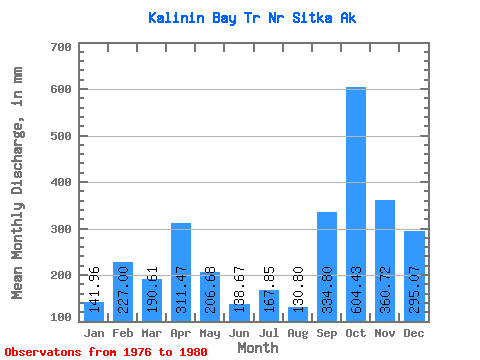
| Statistic | Jan | Feb | Mar | Apr | May | Jun | Jul | Aug | Sep | Oct | Nov | Dec | Annual |
|---|---|---|---|---|---|---|---|---|---|---|---|---|---|
| Mean | 142.13 | 228.81 | 190.41 | 311.61 | 206.58 | 138.87 | 167.82 | 130.94 | 334.83 | 604.49 | 360.88 | 294.95 | 2972.63 |
| Standard Deviation | 118.79 | 259.36 | 19.60 | 142.32 | 67.06 | 36.22 | 85.42 | 83.00 | 164.08 | 169.69 | 130.07 | 173.41 | 93.14 |
| Min | 57.68 | 48.74 | 162.97 | 138.62 | 150.59 | 97.06 | 74.54 | 44.09 | 187.57 | 427.57 | 200.50 | 41.57 | 2913.98 |
| Max | 312.84 | 604.61 | 209.14 | 432.63 | 291.57 | 172.47 | 281.64 | 236.67 | 603.63 | 834.57 | 483.12 | 409.39 | 3080.03 |
| Coefficient of Variation | 0.84 | 1.13 | 0.10 | 0.46 | 0.33 | 0.26 | 0.51 | 0.63 | 0.49 | 0.28 | 0.36 | 0.59 | 0.03 |
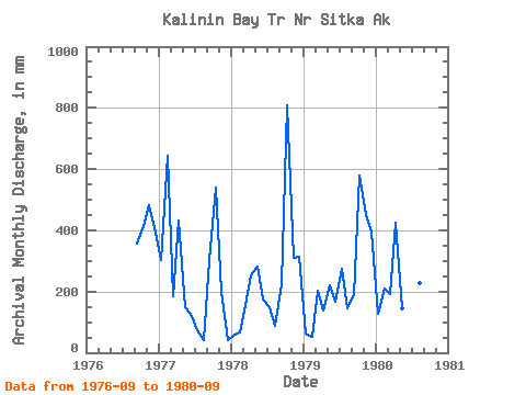
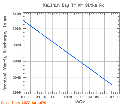
| Year | Jan | Feb | Mar | Apr | May | Jun | Jul | Aug | Sep | Oct | Nov | Dec | Annual | 1976 | 355.09 | 427.57 | 483.12 | 404.77 | 1977 | 312.84 | 604.61 | 192.44 | 432.63 | 155.25 | 120.34 | 74.54 | 44.09 | 304.47 | 558.81 | 200.50 | 41.57 | 3080.03 | 1978 | 57.68 | 63.88 | 162.97 | 251.44 | 291.57 | 172.47 | 153.99 | 91.77 | 223.37 | 834.57 | 311.53 | 324.10 | 2923.88 | 1979 | 64.79 | 48.74 | 209.14 | 138.62 | 228.91 | 165.63 | 281.64 | 151.22 | 187.57 | 597.01 | 448.37 | 409.39 | 2913.98 | 1980 | 133.21 | 197.99 | 197.09 | 423.74 | 150.59 | 97.06 | 161.13 | 236.67 | 603.63 |
|---|
 Return to R-Arctic Net Home Page