|
|
|||||||||||||||||
| Point ID: 9103 | Downloads | Plots | Site Data | Code: 15746991 |
|
|
|||||||||||||||||
| Download | |
|---|---|
| Site Descriptor Information | Site Time Series Data |
| Link to all available data | |
|
|
| View: | Statistics | Time Series |
| Units: | m3/s |
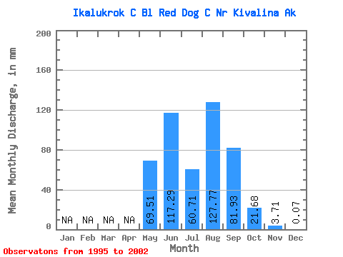
| Statistic | Jan | Feb | Mar | Apr | May | Jun | Jul | Aug | Sep | Oct | Nov | Dec | Annual |
|---|---|---|---|---|---|---|---|---|---|---|---|---|---|
| Mean | 67.25 | 113.47 | 58.73 | 123.61 | 79.27 | 20.97 | 3.60 | 0.06 | |||||
| Standard Deviation | 74.12 | 37.36 | 23.37 | 60.41 | 46.50 | 12.85 | 2.27 | ||||||
| Min | 7.03 | 74.47 | 27.20 | 37.25 | 24.34 | 11.82 | 0.73 | 0.06 | |||||
| Max | 173.68 | 181.34 | 85.44 | 204.11 | 147.96 | 45.28 | 6.17 | 0.06 | |||||
| Coefficient of Variation | 1.10 | 0.33 | 0.40 | 0.49 | 0.59 | 0.61 | 0.63 |
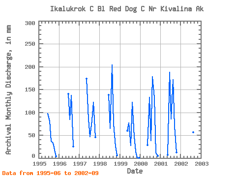
| Year | Jan | Feb | Mar | Apr | May | Jun | Jul | Aug | Sep | Oct | Nov | Dec | Annual | 1995 | 94.48 | 81.42 | 37.31 | 31.44 | 17.28 | 3.19 | 1996 | 135.66 | 84.93 | 137.74 | 24.38 | 1997 | 173.95 | 81.81 | 47.08 | 81.95 | 118.17 | 45.35 | 1998 | 133.48 | 65.34 | 204.43 | 72.88 | 24.96 | 6.18 | 1999 | 59.42 | 74.59 | 27.24 | 122.61 | 45.69 | 14.51 | 0.74 | 0.06 | 2000 | 29.00 | 128.32 | 38.33 | 177.96 | 127.26 | 11.84 | 4.30 | 2001 | 7.04 | 181.62 | 85.57 | 171.57 | 67.17 | 12.09 | 2002 | 79.26 | 40.67 | 56.84 | 148.19 |
|---|
 Return to R-Arctic Net Home Page