|
|
|||||||||||||||||
| Point ID: 9080 | Downloads | Plots | Site Data | Code: 3002 |
|
|
|||||||||||||||||
| Download | |
|---|---|
| Site Descriptor Information | Site Time Series Data |
| Link to all available data | |
|
|
| View: | Statistics | Time Series |
| Units: | m3/s |
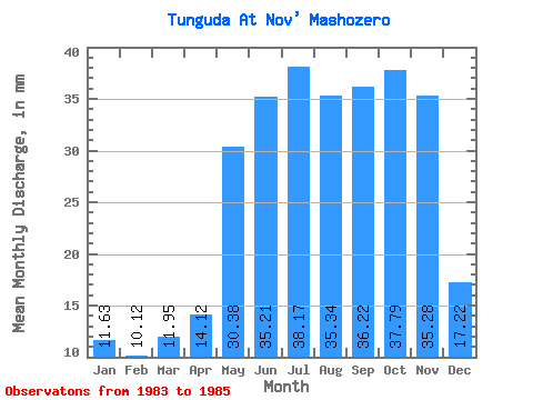
| Statistic | Jan | Feb | Mar | Apr | May | Jun | Jul | Aug | Sep | Oct | Nov | Dec | Annual |
|---|---|---|---|---|---|---|---|---|---|---|---|---|---|
| Mean | 11.63 | 10.21 | 11.95 | 14.12 | 30.37 | 35.21 | 38.16 | 35.34 | 36.22 | 37.79 | 35.28 | 17.22 | 311.01 |
| Standard Deviation | 2.21 | 1.06 | 0.40 | 3.25 | 25.85 | 15.88 | 0.95 | 3.80 | 8.24 | 6.37 | 11.48 | 7.97 | 88.72 |
| Min | 10.06 | 9.46 | 11.67 | 11.81 | 12.10 | 23.98 | 37.49 | 31.02 | 29.38 | 31.24 | 22.90 | 8.39 | 248.27 |
| Max | 13.19 | 10.96 | 12.23 | 16.42 | 48.65 | 46.44 | 38.83 | 38.16 | 45.36 | 43.96 | 45.58 | 23.88 | 373.75 |
| Coefficient of Variation | 0.19 | 0.10 | 0.03 | 0.23 | 0.85 | 0.45 | 0.03 | 0.11 | 0.23 | 0.17 | 0.33 | 0.46 | 0.28 |
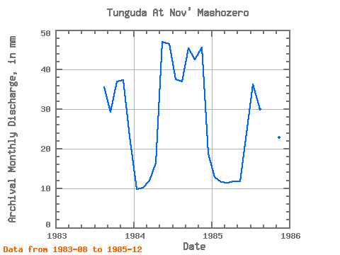
| Year | Jan | Feb | Mar | Apr | May | Jun | Jul | Aug | Sep | Oct | Nov | Dec | Annual | 1983 | 36.82 | 29.38 | 38.16 | 37.37 | 23.88 | 1984 | 10.06 | 9.46 | 12.23 | 16.42 | 48.65 | 46.44 | 38.83 | 38.16 | 45.36 | 43.96 | 45.58 | 19.39 | 373.75 | 1985 | 13.19 | 10.96 | 11.67 | 11.81 | 12.10 | 23.98 | 37.49 | 31.02 | 33.91 | 31.24 | 22.90 | 8.39 | 248.27 |
|---|
 Return to R-Arctic Net Home Page