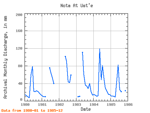
| Point ID: 9045 | Downloads | Plots | Site Data | Code: 71288 |
| Download | |
|---|---|
| Site Descriptor Information | Site Time Series Data |
| Link to all available data | |

|

|
| View: | Statistics | Time Series |
| Units: | m3/s |
| Statistic | Jan | Feb | Mar | Apr | May | Jun | Jul | Aug | Sep | Oct | Nov | Dec | Annual |
|---|---|---|---|---|---|---|---|---|---|---|---|---|---|
| Mean | 13.19 | 10.48 | 10.26 | 9.50 | 90.77 | 72.70 | 46.66 | 37.74 | 36.30 | 35.64 | 19.14 | 15.26 | 365.59 |
| Standard Deviation | 1.74 | 1.44 | 0.60 | 2.15 | 32.57 | 15.12 | 23.72 | 13.90 | 13.04 | 16.52 | 3.84 | 1.79 | 65.84 |
| Min | 11.58 | 8.83 | 9.61 | 7.46 | 50.96 | 48.71 | 22.61 | 21.98 | 22.95 | 21.98 | 15.02 | 13.63 | 303.22 |
| Max | 14.89 | 12.34 | 11.03 | 11.74 | 122.87 | 89.96 | 83.49 | 53.72 | 59.46 | 56.47 | 22.95 | 17.80 | 434.41 |
| Coefficient of Variation | 0.13 | 0.14 | 0.06 | 0.23 | 0.36 | 0.21 | 0.51 | 0.37 | 0.36 | 0.46 | 0.20 | 0.12 | 0.18 |
| Year | Jan | Feb | Mar | Apr | May | Jun | Jul | Aug | Sep | Oct | Nov | Dec | Annual | 1980 | 14.49 | 11.20 | 9.61 | 7.46 | 61.04 | 78.52 | 22.61 | 22.21 | 22.95 | 21.98 | 16.77 | 14.65 | 303.22 | 1981 | 11.58 | 8.83 | 9.69 | 75.62 | 65.69 | 53.72 | 39.57 | 1982 | 104.76 | 89.96 | 44.90 | 43.32 | 59.46 | 1983 | 9.26 | 10.48 | 114.21 | 61.06 | 37.18 | 34.18 | 28.36 | 41.35 | 21.80 | 13.63 | 1984 | 14.89 | 12.34 | 11.03 | 11.74 | 122.87 | 48.71 | 83.49 | 51.04 | 28.82 | 22.76 | 15.02 | 14.96 | 434.41 | 1985 | 11.81 | 10.77 | 10.48 | 9.30 | 50.96 | 82.33 | 26.07 | 21.98 | 38.65 | 56.47 | 22.95 | 17.80 | 359.15 |
|---|
 Return to R-Arctic Net Home Page