|
|
|||||||||||||||||
| Point ID: 9033 | Downloads | Plots | Site Data | Code: 71252 |
|
|
|||||||||||||||||
| Download | |
|---|---|
| Site Descriptor Information | Site Time Series Data |
| Link to all available data | |
|
|
| View: | Statistics | Time Series |
| Units: | m3/s |
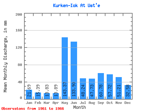
| Statistic | Jan | Feb | Mar | Apr | May | Jun | Jul | Aug | Sep | Oct | Nov | Dec | Annual |
|---|---|---|---|---|---|---|---|---|---|---|---|---|---|
| Mean | 21.69 | 15.53 | 13.83 | 13.89 | 143.35 | 133.91 | 48.23 | 47.71 | 60.79 | 57.71 | 51.21 | 32.58 | 640.63 |
| Standard Deviation | 2.62 | 2.89 | 3.30 | 4.32 | 66.64 | 63.18 | 15.55 | 21.01 | 19.16 | 32.32 | 18.72 | 10.62 | 65.46 |
| Min | 19.72 | 11.13 | 10.15 | 7.97 | 51.94 | 64.52 | 34.58 | 28.84 | 39.45 | 39.29 | 31.05 | 17.36 | 556.20 |
| Max | 26.19 | 19.17 | 18.83 | 17.52 | 210.41 | 213.63 | 66.51 | 67.83 | 90.01 | 115.07 | 71.07 | 42.97 | 699.26 |
| Coefficient of Variation | 0.12 | 0.19 | 0.24 | 0.31 | 0.47 | 0.47 | 0.32 | 0.44 | 0.32 | 0.56 | 0.37 | 0.33 | 0.10 |
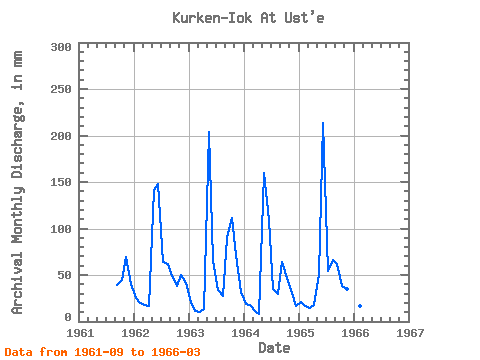
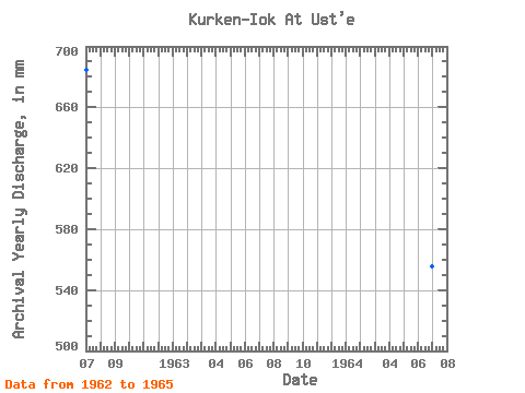
| Year | Jan | Feb | Mar | Apr | May | Jun | Jul | Aug | Sep | Oct | Nov | Dec | Annual | 1961 | 39.45 | 46.20 | 69.22 | 42.08 | 1962 | 26.19 | 19.17 | 18.83 | 16.66 | 146.26 | 148.11 | 66.51 | 63.86 | 48.71 | 39.29 | 50.13 | 42.97 | 684.81 | 1963 | 21.34 | 11.13 | 10.15 | 13.39 | 210.41 | 64.52 | 34.58 | 28.84 | 90.01 | 115.07 | 71.07 | 32.52 | 699.26 | 1964 | 19.72 | 16.36 | 11.77 | 7.97 | 164.80 | 109.38 | 36.05 | 30.31 | 64.37 | 48.56 | 31.05 | 17.36 | 556.20 | 1965 | 21.19 | 15.28 | 14.71 | 17.52 | 51.94 | 213.63 | 55.77 | 67.83 | 61.39 | 39.43 | 34.61 | 27.96 | 622.25 | 1966 | 20.01 | 15.69 | 13.68 |
|---|
 Return to R-Arctic Net Home Page