|
|
|||||||||||||||||
| Point ID: 9021 | Downloads | Plots | Site Data | Code: 71210 |
|
|
|||||||||||||||||
| Download | |
|---|---|
| Site Descriptor Information | Site Time Series Data |
| Link to all available data | |
|
|
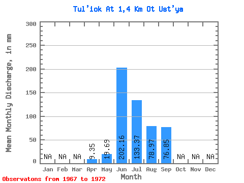
| View: | Statistics | Time Series |
| Units: | m3/s |
| Statistic | Jan | Feb | Mar | Apr | May | Jun | Jul | Aug | Sep | Oct | Nov | Dec | Annual |
|---|---|---|---|---|---|---|---|---|---|---|---|---|---|
| Mean | 9.35 | 19.69 | 202.17 | 133.35 | 78.96 | 76.85 | |||||||
| Standard Deviation | 47.81 | 44.51 | 16.15 | 33.89 | |||||||||
| Min | 9.35 | 19.69 | 144.40 | 85.84 | 60.53 | 51.72 | |||||||
| Max | 9.35 | 19.69 | 269.85 | 174.87 | 98.81 | 115.40 | |||||||
| Coefficient of Variation | 0.24 | 0.33 | 0.20 | 0.44 |
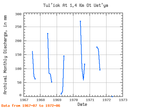
| Year | Jan | Feb | Mar | Apr | May | Jun | Jul | Aug | Sep | Oct | Nov | Dec | Annual | 1967 | 167.53 | 73.37 | 63.44 | 1968 | 224.88 | 85.84 | 83.15 | 51.72 | 1969 | 9.35 | 19.69 | 144.40 | 1970 | 269.85 | 105.16 | 60.53 | 115.40 | 1971 | 176.43 | 174.87 | 98.81 | 1972 | 195.29 |
|---|
 Return to R-Arctic Net Home Page