|
|
|||||||||||||||||
| Point ID: 9004 | Downloads | Plots | Site Data | Code: 71161 |
|
|
|||||||||||||||||
| Download | |
|---|---|
| Site Descriptor Information | Site Time Series Data |
| Link to all available data | |
|
|
| View: | Statistics | Time Series |
| Units: | m3/s |
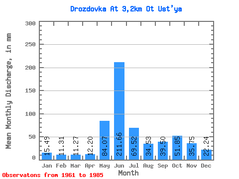
| Statistic | Jan | Feb | Mar | Apr | May | Jun | Jul | Aug | Sep | Oct | Nov | Dec | Annual |
|---|---|---|---|---|---|---|---|---|---|---|---|---|---|
| Mean | 15.49 | 11.40 | 11.27 | 12.21 | 84.06 | 211.66 | 69.51 | 34.52 | 39.50 | 51.84 | 35.74 | 22.24 | 603.44 |
| Standard Deviation | 3.13 | 2.82 | 3.40 | 4.78 | 68.42 | 58.46 | 45.68 | 20.25 | 19.39 | 28.45 | 14.71 | 5.02 | 91.80 |
| Min | 9.85 | 5.74 | 6.56 | 5.08 | 9.26 | 120.07 | 25.27 | 8.99 | 17.28 | 22.18 | 20.27 | 13.06 | 462.06 |
| Max | 20.94 | 16.15 | 17.52 | 23.44 | 227.76 | 340.52 | 212.66 | 80.73 | 75.60 | 146.37 | 78.78 | 37.74 | 740.01 |
| Coefficient of Variation | 0.20 | 0.25 | 0.30 | 0.39 | 0.81 | 0.28 | 0.66 | 0.59 | 0.49 | 0.55 | 0.41 | 0.23 | 0.15 |
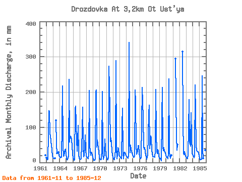
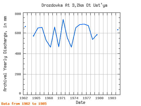
| Year | Jan | Feb | Mar | Apr | May | Jun | Jul | Aug | Sep | Oct | Nov | Dec | Annual | 1961 | 20.27 | 1962 | 14.44 | 10.59 | 7.94 | 9.91 | 151.62 | 145.48 | 82.70 | 80.73 | 58.19 | 50.61 | 35.26 | 20.15 | 664.78 | 1963 | 14.57 | 11.60 | 10.96 | 12.07 | 120.07 | 53.30 | 28.09 | 29.35 | 19.96 | 1964 | 16.15 | 13.34 | 16.41 | 15.06 | 106.99 | 217.91 | 48.83 | 18.12 | 19.69 | 37.74 | 38.24 | 22.78 | 571.77 | 1965 | 16.08 | 8.07 | 8.21 | 14.99 | 17.20 | 235.69 | 59.27 | 78.11 | 72.42 | 67.61 | 46.88 | 23.76 | 649.51 | 1966 | 14.51 | 8.61 | 6.56 | 7.24 | 157.53 | 160.09 | 66.29 | 32.88 | 61.12 | 108.30 | 21.92 | 13.06 | 655.31 | 1967 | 9.85 | 8.13 | 10.04 | 10.04 | 89.92 | 156.28 | 44.70 | 17.13 | 19.19 | 48.97 | 78.78 | 37.74 | 530.64 | 1968 | 19.23 | 13.22 | 12.54 | 11.24 | 22.71 | 203.93 | 46.60 | 35.51 | 20.77 | 30.72 | 26.49 | 17.52 | 462.06 | 1969 | 10.24 | 5.74 | 7.68 | 6.86 | 9.26 | 201.39 | 212.66 | 45.09 | 63.27 | 53.56 | 29.61 | 15.16 | 659.05 | 1970 | 10.30 | 9.39 | 7.75 | 8.70 | 38.73 | 202.02 | 25.34 | 8.99 | 22.23 | 68.92 | 42.12 | 19.89 | 465.92 | 1971 | 16.61 | 11.60 | 7.68 | 7.50 | 14.05 | 272.54 | 160.81 | 61.37 | 69.25 | 56.84 | 34.37 | 21.14 | 734.21 | 1972 | 15.75 | 10.05 | 9.19 | 7.43 | 36.82 | 289.06 | 45.75 | 11.49 | 22.74 | 43.71 | 36.97 | 22.45 | 554.11 | 1973 | 18.84 | 13.52 | 12.21 | 11.37 | 108.30 | 154.38 | 25.27 | 11.55 | 27.06 | 30.98 | 27.38 | 23.04 | 464.05 | 1974 | 17.92 | 13.52 | 14.38 | 11.69 | 19.69 | 340.52 | 66.29 | 28.49 | 49.17 | 38.27 | 26.17 | 22.84 | 652.54 | 1975 | 18.38 | 14.53 | 15.36 | 18.80 | 212.66 | 171.53 | 52.38 | 24.16 | 32.91 | 49.16 | 47.90 | 27.83 | 683.54 | 1976 | 17.72 | 12.14 | 11.42 | 14.36 | 111.58 | 212.82 | 132.59 | 44.50 | 37.35 | 43.19 | 32.27 | 19.82 | 688.25 | 1977 | 18.12 | 9.33 | 16.34 | 19.19 | 142.43 | 163.27 | 40.96 | 58.02 | 75.60 | 72.20 | 33.29 | 26.52 | 673.55 | 1978 | 17.07 | 16.03 | 17.52 | 14.74 | 32.88 | 207.74 | 87.30 | 31.31 | 25.09 | 37.28 | 31.83 | 18.90 | 538.70 | 1979 | 11.42 | 11.54 | 7.55 | 5.08 | 131.28 | 213.46 | 44.17 | 35.44 | 42.25 | 33.15 | 26.43 | 23.10 | 584.85 | 1980 | 15.95 | 14.29 | 13.59 | 10.16 | 26.06 | 237.60 | 29.14 | 12.34 | 17.28 | 22.18 | 1981 | 294.78 | 74.83 | 35.84 | 50.89 | 1982 | 315.11 | 126.02 | 26.98 | 22.11 | 31.70 | 23.06 | 20.02 | 1983 | 15.03 | 12.02 | 11.22 | 23.44 | 98.46 | 177.88 | 56.38 | 54.41 | 46.88 | 146.37 | 73.69 | 25.86 | 740.01 | 1984 | 20.94 | 16.15 | 14.51 | 19.25 | 227.76 | 140.40 | 51.13 | 35.44 | 31.57 | 31.51 | 25.22 | 20.54 | 631.65 | 1985 | 11.75 | 7.47 | 8.86 | 9.40 | 9.39 | 245.86 | 35.58 | 12.54 | 21.47 | 37.61 | 34.62 | 27.17 | 464.31 |
|---|
 Return to R-Arctic Net Home Page