|
|
|||||||||||||||||
| Point ID: 8982 | Downloads | Plots | Site Data | Code: 71107 |
|
|
|||||||||||||||||
| Download | |
|---|---|
| Site Descriptor Information | Site Time Series Data |
| Link to all available data | |
|
|
| View: | Statistics | Time Series |
| Units: | m3/s |
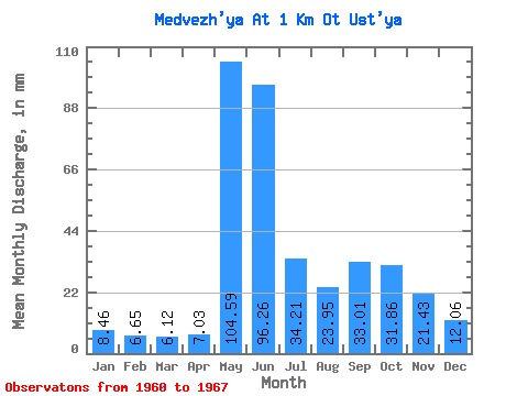
| Statistic | Jan | Feb | Mar | Apr | May | Jun | Jul | Aug | Sep | Oct | Nov | Dec | Annual |
|---|---|---|---|---|---|---|---|---|---|---|---|---|---|
| Mean | 8.46 | 6.71 | 6.12 | 7.03 | 104.57 | 96.26 | 34.20 | 23.94 | 33.01 | 31.86 | 21.43 | 12.06 | 414.48 |
| Standard Deviation | 2.21 | 0.89 | 0.86 | 2.23 | 50.01 | 61.33 | 13.73 | 15.38 | 12.92 | 14.96 | 7.28 | 3.76 | 32.97 |
| Min | 5.90 | 5.42 | 5.02 | 4.74 | 39.52 | 38.66 | 12.36 | 6.58 | 10.70 | 9.62 | 5.27 | 4.47 | 380.58 |
| Max | 12.95 | 8.30 | 7.46 | 10.94 | 164.90 | 193.89 | 55.67 | 49.34 | 53.88 | 50.19 | 26.37 | 15.94 | 456.00 |
| Coefficient of Variation | 0.26 | 0.13 | 0.14 | 0.32 | 0.48 | 0.64 | 0.40 | 0.64 | 0.39 | 0.47 | 0.34 | 0.31 | 0.08 |
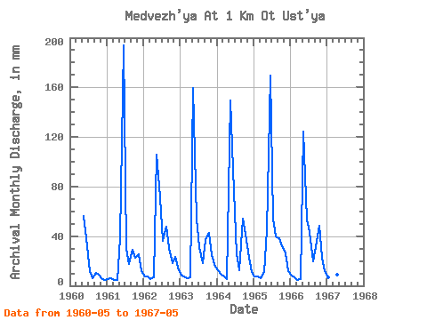
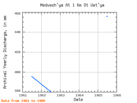
| Year | Jan | Feb | Mar | Apr | May | Jun | Jul | Aug | Sep | Oct | Nov | Dec | Annual | 1960 | 58.20 | 38.66 | 12.36 | 6.58 | 10.70 | 9.62 | 5.27 | 4.47 | 1961 | 5.90 | 5.42 | 5.14 | 4.74 | 39.52 | 193.89 | 30.62 | 18.47 | 29.23 | 23.57 | 25.10 | 12.48 | 395.78 | 1962 | 7.84 | 6.76 | 5.78 | 6.78 | 109.23 | 71.03 | 37.16 | 49.34 | 30.37 | 19.10 | 23.63 | 15.48 | 380.58 | 1963 | 8.56 | 6.84 | 6.37 | 6.90 | 164.90 | 53.88 | 32.26 | 18.89 | 37.02 | 43.86 | 24.94 | 15.94 | 417.49 | 1964 | 12.95 | 8.30 | 7.46 | 5.63 | 154.35 | 93.47 | 26.65 | 12.90 | 53.88 | 43.44 | 22.37 | 11.64 | 451.45 | 1965 | 8.14 | 7.11 | 6.58 | 10.94 | 45.97 | 169.81 | 55.67 | 40.82 | 38.37 | 33.23 | 26.37 | 12.48 | 456.00 | 1966 | 8.77 | 6.34 | 5.02 | 5.22 | 128.63 | 53.06 | 44.70 | 20.58 | 31.51 | 50.19 | 22.33 | 11.89 | 385.55 | 1967 | 7.04 | 6.19 | 6.45 | 9.02 | 135.80 |
|---|
 Return to R-Arctic Net Home Page