|
|
|||||||||||||||||
| Point ID: 8955 | Downloads | Plots | Site Data | Code: 71033 |
|
|
|||||||||||||||||
| Download | |
|---|---|
| Site Descriptor Information | Site Time Series Data |
| Link to all available data | |
|
|
| View: | Statistics | Time Series |
| Units: | m3/s |
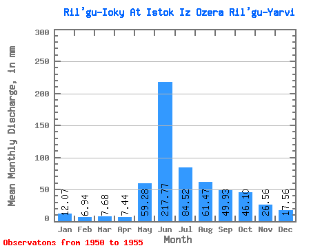
| Statistic | Jan | Feb | Mar | Apr | May | Jun | Jul | Aug | Sep | Oct | Nov | Dec | Annual |
|---|---|---|---|---|---|---|---|---|---|---|---|---|---|
| Mean | 11.85 | 7.20 | 7.13 | 6.91 | 58.72 | 217.98 | 84.51 | 61.02 | 50.35 | 45.66 | 26.56 | 17.20 | 649.96 |
| Standard Deviation | 8.41 | 5.40 | 3.75 | 3.07 | 37.05 | 104.97 | 63.14 | 41.01 | 56.38 | 21.66 | 14.95 | 9.78 | 252.08 |
| Min | 0.00 | 0.00 | 2.19 | 3.19 | 20.85 | 91.36 | 29.63 | 25.24 | 4.25 | 26.34 | 1.06 | 0.00 | 391.27 |
| Max | 21.95 | 14.00 | 10.97 | 10.62 | 97.68 | 308.07 | 186.58 | 131.71 | 148.72 | 82.32 | 41.43 | 26.34 | 969.00 |
| Coefficient of Variation | 0.71 | 0.75 | 0.53 | 0.44 | 0.63 | 0.48 | 0.75 | 0.67 | 1.12 | 0.47 | 0.56 | 0.57 | 0.39 |
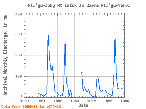
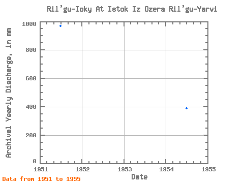
| Year | Jan | Feb | Mar | Apr | May | Jun | Jul | Aug | Sep | Oct | Nov | Dec | Annual | 1950 | 19.12 | 15.37 | 1951 | 13.17 | 8.00 | 6.58 | 10.62 | 20.85 | 308.07 | 186.58 | 131.71 | 148.72 | 82.32 | 26.56 | 26.34 | 969.00 | 1952 | 16.46 | 10.00 | 8.78 | 6.37 | 34.02 | 276.20 | 72.44 | 52.68 | 4.25 | 36.22 | 1.06 | 0.00 | 519.53 | 1953 | 0.00 | 0.00 | 116.85 | 29.63 | 51.58 | 33.99 | 26.34 | 39.30 | 14.27 | 1954 | 7.68 | 4.00 | 2.19 | 3.19 | 97.68 | 91.36 | 37.32 | 25.24 | 32.93 | 37.32 | 31.87 | 21.95 | 391.27 | 1955 | 21.95 | 14.00 | 10.97 | 7.44 | 82.32 | 297.44 | 96.58 | 43.90 | 31.87 | 46.10 | 41.43 | 25.24 | 720.02 |
|---|
 Return to R-Arctic Net Home Page