|
|
|||||||||||||||||
| Point ID: 8938 | Downloads | Plots | Site Data | Code: 70610 |
|
|
|||||||||||||||||
| Download | |
|---|---|
| Site Descriptor Information | Site Time Series Data |
| Link to all available data | |
|
|
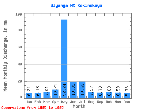
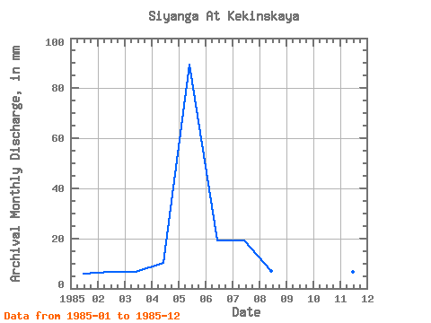
| View: | Statistics | Time Series |
| Units: | m3/s |
| Statistic | Jan | Feb | Mar | Apr | May | Jun | Jul | Aug | Sep | Oct | Nov | Dec | Annual |
|---|---|---|---|---|---|---|---|---|---|---|---|---|---|
| Mean | 6.21 | 6.23 | 7.00 | 10.21 | 92.22 | 19.05 | 19.69 | 7.37 | 6.79 | 6.83 | 6.53 | 5.76 | 192.39 |
| Standard Deviation | |||||||||||||
| Min | 6.21 | 6.23 | 7.00 | 10.21 | 92.22 | 19.05 | 19.69 | 7.37 | 6.79 | 6.83 | 6.53 | 5.76 | 192.39 |
| Max | 6.21 | 6.23 | 7.00 | 10.21 | 92.22 | 19.05 | 19.69 | 7.37 | 6.79 | 6.83 | 6.53 | 5.76 | 192.39 |
| Coefficient of Variation |
| Year | Jan | Feb | Mar | Apr | May | Jun | Jul | Aug | Sep | Oct | Nov | Dec | Annual | 1985 | 6.21 | 6.23 | 7.00 | 10.21 | 92.22 | 19.05 | 19.69 | 7.37 | 6.79 | 6.83 | 6.53 | 5.76 | 192.39 |
|---|
 Return to R-Arctic Net Home Page