|
|
|||||||||||||||||
| Point ID: 8788 | Downloads | Plots | Site Data | Code: 12207 |
|
|
|||||||||||||||||
| Download | |
|---|---|
| Site Descriptor Information | Site Time Series Data |
| Link to all available data | |
|
|
| View: | Statistics | Time Series |
| Units: | m3/s |
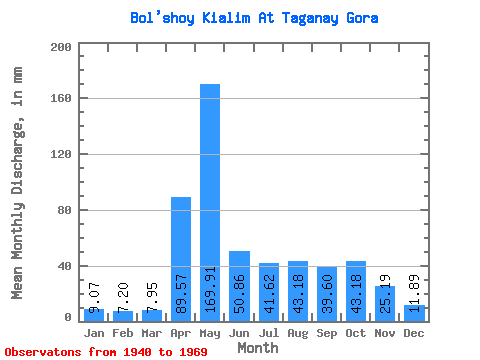
| Statistic | Jan | Feb | Mar | Apr | May | Jun | Jul | Aug | Sep | Oct | Nov | Dec | Annual |
|---|---|---|---|---|---|---|---|---|---|---|---|---|---|
| Mean | 9.05 | 7.26 | 7.95 | 89.56 | 169.88 | 50.86 | 41.62 | 43.17 | 39.59 | 43.19 | 25.18 | 11.88 | 531.05 |
| Standard Deviation | 3.11 | 2.36 | 2.15 | 46.41 | 73.78 | 37.42 | 29.33 | 38.90 | 28.78 | 22.84 | 15.16 | 4.95 | 120.87 |
| Min | 4.48 | 3.06 | 3.36 | 19.77 | 48.43 | 7.04 | 6.16 | 5.32 | 6.25 | 8.39 | 5.69 | 6.44 | 230.48 |
| Max | 17.91 | 11.98 | 12.87 | 166.04 | 349.79 | 172.80 | 116.41 | 150.83 | 109.96 | 113.61 | 78.82 | 24.08 | 782.13 |
| Coefficient of Variation | 0.34 | 0.33 | 0.27 | 0.52 | 0.43 | 0.74 | 0.70 | 0.90 | 0.73 | 0.53 | 0.60 | 0.42 | 0.23 |
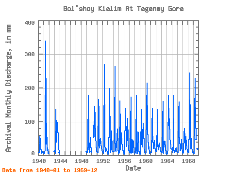
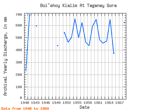
| Year | Jan | Feb | Mar | Apr | May | Jun | Jul | Aug | Sep | Oct | Nov | Dec | Annual | 1940 | 8.13 | 8.68 | 9.81 | 55.00 | 48.43 | 30.89 | 26.89 | 8.13 | 6.25 | 8.39 | 12.20 | 7.57 | 230.48 | 1941 | 7.28 | 6.63 | 7.28 | 19.77 | 349.79 | 115.65 | 34.42 | 98.80 | 13.54 | 22.95 | 10.29 | 7.00 | 686.78 | 1943 | 12.87 | 11.98 | 7.28 | 136.51 | 74.72 | 40.09 | 47.85 | 101.86 | 89.11 | 45.05 | 21.67 | 7.55 | 596.35 | 1949 | 11.47 | 9.18 | 9.23 | 34.67 | 184.41 | 32.50 | 26.02 | 9.51 | 20.04 | 55.97 | 33.04 | 11.75 | 434.76 | 1950 | 90.67 | 52.27 | 58.20 | 150.83 | 109.96 | 53.17 | 34.13 | 10.63 | 1951 | 8.39 | 7.15 | 7.57 | 166.04 | 129.86 | 30.35 | 23.53 | 47.03 | 49.58 | 34.44 | 22.77 | 15.13 | 541.57 | 1952 | 11.75 | 6.88 | 5.88 | 26.27 | 277.87 | 31.42 | 39.46 | 10.63 | 12.73 | 19.31 | 17.06 | 7.83 | 462.24 | 1953 | 4.48 | 3.82 | 5.88 | 100.48 | 204.84 | 32.77 | 20.15 | 9.23 | 21.94 | 75.00 | 13.54 | 13.15 | 502.09 | 1954 | 11.47 | 9.69 | 10.63 | 81.53 | 271.72 | 56.61 | 14.55 | 12.31 | 34.40 | 54.57 | 78.82 | 21.55 | 655.16 | 1955 | 6.16 | 5.35 | 7.83 | 160.63 | 87.87 | 15.98 | 53.73 | 68.56 | 33.04 | 33.86 | 20.04 | 9.51 | 501.56 | 1956 | 6.16 | 3.06 | 4.76 | 139.22 | 101.86 | 72.32 | 37.22 | 26.86 | 59.31 | 113.61 | 41.71 | 17.91 | 623.28 | 1957 | 11.75 | 8.41 | 8.12 | 90.73 | 178.53 | 7.04 | 11.47 | 48.41 | 9.48 | 45.33 | 37.65 | 8.12 | 462.24 | 1958 | 7.28 | 6.63 | 8.68 | 36.56 | 183.57 | 20.04 | 6.16 | 5.32 | 69.88 | 68.84 | 16.81 | 7.29 | 434.52 | 1959 | 6.44 | 3.57 | 3.36 | 135.15 | 119.77 | 36.56 | 25.18 | 59.88 | 95.88 | 73.32 | 28.44 | 7.83 | 594.70 | 1960 | 6.72 | 6.12 | 7.55 | 143.28 | 221.92 | 81.25 | 68.56 | 58.48 | 18.96 | 26.02 | 5.69 | 6.44 | 648.03 | 1961 | 9.79 | 7.39 | 8.12 | 81.25 | 143.27 | 39.54 | 58.48 | 21.27 | 34.13 | 44.77 | 25.19 | 13.43 | 484.50 | 1962 | 11.75 | 10.20 | 12.87 | 104.00 | 142.16 | 33.59 | 17.63 | 25.75 | 36.84 | 32.46 | 17.06 | 13.43 | 456.75 | 1963 | 9.51 | 8.41 | 9.51 | 100.21 | 165.10 | 18.42 | 7.00 | 42.81 | 42.79 | 41.70 | 22.48 | 6.73 | 472.98 | 1964 | 4.49 | 3.84 | 5.88 | 19.79 | 183.01 | 101.30 | 91.50 | 111.65 | 46.31 | 46.73 | 20.31 | 20.15 | 649.72 | 1965 | 17.91 | 10.96 | 10.35 | 39.54 | 183.57 | 19.50 | 10.07 | 15.67 | 10.83 | 21.28 | 22.75 | 11.75 | 371.57 | 1966 | 10.35 | 6.88 | 9.51 | 132.44 | 163.70 | 52.81 | 54.01 | 15.67 | 15.71 | 26.58 | 46.87 | 24.08 | 557.36 | 1967 | 8.39 | 6.63 | 8.39 | 61.75 | 81.99 | 71.23 | 58.20 | 17.63 | 55.25 | 36.10 | 22.21 | 13.99 | 441.36 | 1968 | 8.96 | 6.88 | 8.96 | 85.59 | 252.69 | 55.79 | 92.06 | 19.59 | 49.56 | 24.07 | 13.81 | 10.07 | 624.11 | 1969 | 6.72 | 8.67 | 5.32 | 109.42 | 235.90 | 172.80 | 116.41 | 50.09 | 14.63 | 33.02 | 19.77 | 12.31 | 782.13 |
|---|
 Return to R-Arctic Net Home Page