|
|
|||||||||||||||||
| Point ID: 8770 | Downloads | Plots | Site Data | Code: 12079 |
|
|
|||||||||||||||||
| Download | |
|---|---|
| Site Descriptor Information | Site Time Series Data |
| Link to all available data | |
|
|
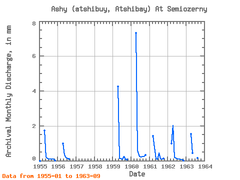
| View: | Statistics | Time Series |
| Units: | m3/s |
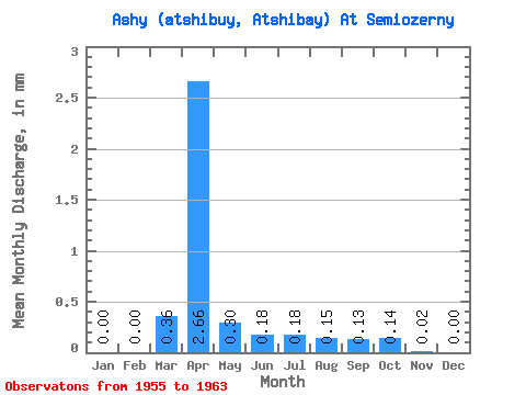
| Statistic | Jan | Feb | Mar | Apr | May | Jun | Jul | Aug | Sep | Oct | Nov | Dec | Annual |
|---|---|---|---|---|---|---|---|---|---|---|---|---|---|
| Mean | 0.00 | 0.00 | 0.32 | 2.41 | 0.27 | 0.16 | 0.17 | 0.14 | 0.12 | 0.13 | 0.02 | 0.00 | 2.87 |
| Standard Deviation | 0.00 | 0.00 | 0.56 | 2.14 | 0.16 | 0.08 | 0.12 | 0.07 | 0.07 | 0.10 | 0.01 | 0.00 | 0.81 |
| Min | 0.00 | 0.00 | 0.00 | 0.69 | 0.12 | 0.07 | 0.08 | 0.08 | 0.07 | 0.07 | 0.02 | 0.00 | 2.29 |
| Max | 0.00 | 0.00 | 1.33 | 6.65 | 0.55 | 0.29 | 0.41 | 0.23 | 0.22 | 0.30 | 0.02 | 0.00 | 3.44 |
| Coefficient of Variation | 1.74 | 0.89 | 0.59 | 0.48 | 0.72 | 0.49 | 0.55 | 0.76 | 0.25 | 0.28 |
| Year | Jan | Feb | Mar | Apr | May | Jun | Jul | Aug | Sep | Oct | Nov | Dec | Annual | 1955 | 0.00 | 0.00 | 0.01 | 1.57 | 0.21 | 0.12 | 0.09 | 0.08 | 0.09 | 0.09 | 0.02 | 0.00 | 2.29 | 1956 | 0.00 | 0.00 | 0.00 | 0.89 | 0.32 | 0.18 | 0.11 | 0.09 | 0.00 | 1959 | 0.00 | 0.00 | 0.00 | 3.86 | 0.12 | 0.10 | 0.08 | 0.23 | 0.07 | 0.07 | 1960 | 0.00 | 0.00 | 0.00 | 6.65 | 0.55 | 0.22 | 0.21 | 0.23 | 0.22 | 0.30 | 1961 | 0.00 | 0.00 | 1.33 | 0.69 | 0.12 | 0.07 | 0.41 | 0.08 | 0.08 | 0.11 | 1962 | 0.00 | 0.00 | 0.94 | 1.82 | 0.19 | 0.13 | 0.10 | 0.09 | 0.07 | 0.07 | 0.02 | 0.00 | 3.44 | 1963 | 0.00 | 0.00 | 0.00 | 1.37 | 0.41 | 0.29 | 0.15 | 0.16 | 0.19 |
|---|
 Return to R-Arctic Net Home Page