|
|
|||||||||||||||||
| Point ID: 8763 | Downloads | Plots | Site Data | Code: 12044 |
|
|
|||||||||||||||||
| Download | |
|---|---|
| Site Descriptor Information | Site Time Series Data |
| Link to all available data | |
|
|
| View: | Statistics | Time Series |
| Units: | m3/s |
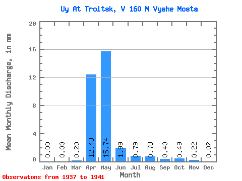
| Statistic | Jan | Feb | Mar | Apr | May | Jun | Jul | Aug | Sep | Oct | Nov | Dec | Annual |
|---|---|---|---|---|---|---|---|---|---|---|---|---|---|
| Mean | 0.00 | 0.00 | 0.20 | 12.43 | 15.74 | 1.98 | 0.80 | 0.78 | 0.40 | 0.49 | 0.22 | 0.02 | 32.96 |
| Standard Deviation | 0.01 | 0.00 | 0.43 | 9.71 | 31.44 | 2.42 | 0.60 | 0.81 | 0.47 | 0.50 | 0.19 | 0.03 | 44.85 |
| Min | 0.00 | 0.00 | 0.00 | 3.20 | 1.26 | 0.72 | 0.40 | 0.21 | 0.13 | 0.16 | 0.12 | 0.00 | 6.42 |
| Max | 0.02 | 0.00 | 0.97 | 28.07 | 71.98 | 6.31 | 1.85 | 2.12 | 1.24 | 1.36 | 0.57 | 0.07 | 112.69 |
| Coefficient of Variation | 2.24 | 2.22 | 0.78 | 2.00 | 1.22 | 0.75 | 1.03 | 1.18 | 1.02 | 0.86 | 1.33 | 1.36 |
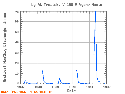
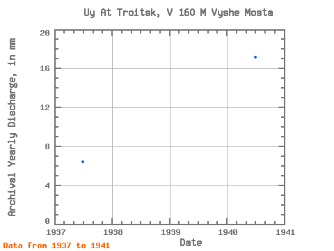
| Year | Jan | Feb | Mar | Apr | May | Jun | Jul | Aug | Sep | Oct | Nov | Dec | Annual | 1937 | 0.00 | 0.00 | 0.01 | 3.20 | 1.36 | 0.72 | 0.49 | 0.21 | 0.13 | 0.16 | 0.12 | 0.01 | 6.42 | 1938 | 0.00 | 0.00 | 0.00 | 12.35 | 2.56 | 1.03 | 0.71 | 0.96 | 0.25 | 0.34 | 0.13 | 0.00 | 18.45 | 1939 | 0.00 | 0.00 | 0.97 | 5.58 | 1.26 | 0.74 | 0.54 | 0.32 | 0.20 | 0.27 | 0.12 | 0.00 | 10.04 | 1940 | 0.00 | 0.00 | 0.00 | 12.94 | 1.54 | 1.13 | 0.40 | 0.29 | 0.18 | 0.30 | 0.18 | 0.07 | 17.20 | 1941 | 0.02 | 0.00 | 0.00 | 28.07 | 71.98 | 6.31 | 1.85 | 2.12 | 1.24 | 1.36 | 0.57 | 0.03 | 112.69 |
|---|
 Return to R-Arctic Net Home Page