|
|
|||||||||||||||||
| Point ID: 8759 | Downloads | Plots | Site Data | Code: 12031 |
|
|
|||||||||||||||||
| Download | |
|---|---|
| Site Descriptor Information | Site Time Series Data |
| Link to all available data | |
|
|
| View: | Statistics | Time Series |
| Units: | m3/s |
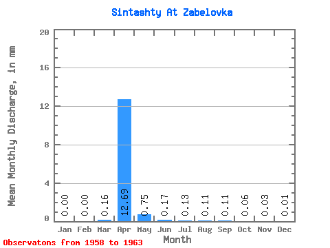
| Statistic | Jan | Feb | Mar | Apr | May | Jun | Jul | Aug | Sep | Oct | Nov | Dec | Annual |
|---|---|---|---|---|---|---|---|---|---|---|---|---|---|
| Mean | 0.00 | 0.00 | 0.16 | 12.69 | 0.75 | 0.17 | 0.13 | 0.11 | 0.11 | 0.06 | 0.03 | 0.01 | 10.01 |
| Standard Deviation | 0.00 | 0.00 | 0.35 | 9.21 | 0.71 | 0.14 | 0.12 | 0.12 | 0.10 | 0.05 | 0.03 | 0.02 | 6.51 |
| Min | 0.00 | 0.00 | 0.00 | 3.73 | 0.29 | 0.02 | 0.02 | 0.02 | 0.01 | 0.01 | 0.01 | 0.00 | 5.34 |
| Max | 0.00 | 0.00 | 0.79 | 23.85 | 2.01 | 0.40 | 0.34 | 0.33 | 0.28 | 0.14 | 0.08 | 0.04 | 17.44 |
| Coefficient of Variation | 2.20 | 0.72 | 0.96 | 0.86 | 0.93 | 1.07 | 0.91 | 0.82 | 1.03 | 1.73 | 0.65 |
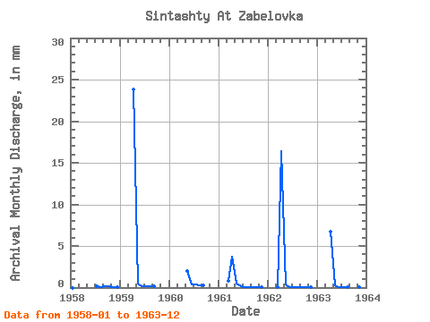
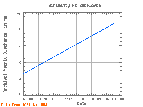
| Year | Jan | Feb | Mar | Apr | May | Jun | Jul | Aug | Sep | Oct | Nov | Dec | Annual | 1958 | 0.00 | 0.00 | 0.00 | 0.11 | 0.05 | 0.14 | 0.14 | 0.08 | 0.04 | 1959 | 0.00 | 0.00 | 0.00 | 23.85 | 0.54 | 0.20 | 0.16 | 0.19 | 0.15 | 1960 | 0.00 | 0.00 | 2.01 | 0.40 | 0.34 | 0.33 | 0.28 | 1961 | 0.00 | 0.00 | 0.79 | 3.73 | 0.46 | 0.12 | 0.05 | 0.04 | 0.04 | 0.06 | 0.01 | 0.00 | 5.34 | 1962 | 0.00 | 0.00 | 0.01 | 16.45 | 0.44 | 0.09 | 0.07 | 0.05 | 0.04 | 0.05 | 0.02 | 0.00 | 17.44 | 1963 | 0.00 | 0.00 | 0.00 | 6.75 | 0.29 | 0.02 | 0.02 | 0.02 | 0.01 | 0.01 | 0.01 | 0.00 | 7.24 |
|---|
 Return to R-Arctic Net Home Page