|
|
|||||||||||||||||
| Point ID: 8749 | Downloads | Plots | Site Data | Code: 12635 |
|
|
|||||||||||||||||
| Download | |
|---|---|
| Site Descriptor Information | Site Time Series Data |
| Link to all available data | |
|
|
| View: | Statistics | Time Series |
| Units: | m3/s |
| Statistic | Jan | Feb | Mar | Apr | May | Jun | Jul | Aug | Sep | Oct | Nov | Dec | Annual |
|---|---|---|---|---|---|---|---|---|---|---|---|---|---|
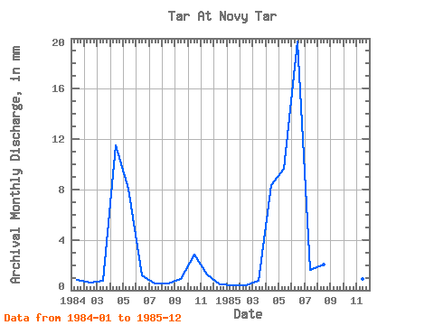
| Mean | 0.64 | 0.49 | 0.79 | 9.93 | 9.15 | 10.47 | 1.11 | 1.31 | 0.80 | 1.95 | 1.08 | 0.71 | 38.51 |
| Standard Deviation | 0.33 | 0.12 | 0.03 | 2.23 | 1.14 | 13.15 | 0.78 | 1.09 | 0.10 | 1.39 | 0.26 | 0.33 | 12.13 |
| Min | 0.41 | 0.40 | 0.77 | 8.35 | 8.34 | 1.18 | 0.56 | 0.54 | 0.73 | 0.96 | 0.90 | 0.48 | 29.93 |
| Max | 0.87 | 0.58 | 0.81 | 11.51 | 9.96 | 19.77 | 1.66 | 2.08 | 0.88 | 2.93 | 1.27 | 0.94 | 47.09 |
| Coefficient of Variation | 0.51 | 0.25 | 0.03 | 0.22 | 0.12 | 1.26 | 0.70 | 0.83 | 0.13 | 0.71 | 0.24 | 0.46 | 0.32 |
| Year | Jan | Feb | Mar | Apr | May | Jun | Jul | Aug | Sep | Oct | Nov | Dec | Annual | 1984 | 0.87 | 0.58 | 0.81 | 11.51 | 8.34 | 1.18 | 0.56 | 0.54 | 0.88 | 2.93 | 1.27 | 0.48 | 29.93 | 1985 | 0.41 | 0.40 | 0.77 | 8.35 | 9.96 | 19.77 | 1.66 | 2.08 | 0.73 | 0.96 | 0.90 | 0.94 | 47.09 |
|---|
 Return to R-Arctic Net Home Page
