|
|
|||||||||||||||||
| Point ID: 8746 | Downloads | Plots | Site Data | Code: 12632 |
|
|
|||||||||||||||||
| Download | |
|---|---|
| Site Descriptor Information | Site Time Series Data |
| Link to all available data | |
|
|
| View: | Statistics | Time Series |
| Units: | m3/s |
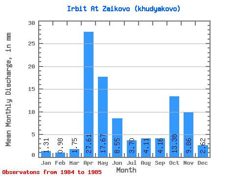
| Statistic | Jan | Feb | Mar | Apr | May | Jun | Jul | Aug | Sep | Oct | Nov | Dec | Annual |
|---|---|---|---|---|---|---|---|---|---|---|---|---|---|
| Mean | 1.31 | 0.98 | 1.75 | 27.61 | 17.66 | 8.55 | 3.70 | 4.11 | 4.16 | 13.37 | 9.86 | 2.62 | 95.71 |
| Standard Deviation | 0.53 | 0.55 | 1.50 | 38.91 | 0.34 | 0.50 | 2.35 | 2.09 | 2.72 | 15.31 | 12.01 | 1.73 | 13.90 |
| Min | 0.94 | 0.59 | 0.69 | 0.09 | 17.42 | 8.20 | 2.04 | 2.63 | 2.24 | 2.55 | 1.37 | 1.40 | 85.88 |
| Max | 1.69 | 1.37 | 2.81 | 55.12 | 17.91 | 8.90 | 5.36 | 5.58 | 6.08 | 24.20 | 18.35 | 3.85 | 105.54 |
| Coefficient of Variation | 0.40 | 0.56 | 0.85 | 1.41 | 0.02 | 0.06 | 0.64 | 0.51 | 0.65 | 1.15 | 1.22 | 0.66 | 0.14 |
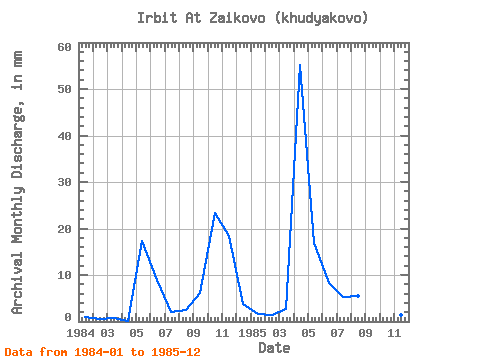
| Year | Jan | Feb | Mar | Apr | May | Jun | Jul | Aug | Sep | Oct | Nov | Dec | Annual | 1984 | 0.94 | 0.59 | 0.69 | 0.09 | 17.91 | 8.90 | 2.04 | 2.63 | 6.08 | 24.20 | 18.35 | 3.85 | 85.88 | 1985 | 1.69 | 1.37 | 2.81 | 55.12 | 17.42 | 8.20 | 5.36 | 5.58 | 2.24 | 2.55 | 1.37 | 1.40 | 105.54 |
|---|
 Return to R-Arctic Net Home Page