|
|
|||||||||||||||||
| Point ID: 8707 | Downloads | Plots | Site Data | Code: 11672 |
|
|
|||||||||||||||||
| Download | |
|---|---|
| Site Descriptor Information | Site Time Series Data |
| Link to all available data | |
|
|
| View: | Statistics | Time Series |
| Units: | m3/s |
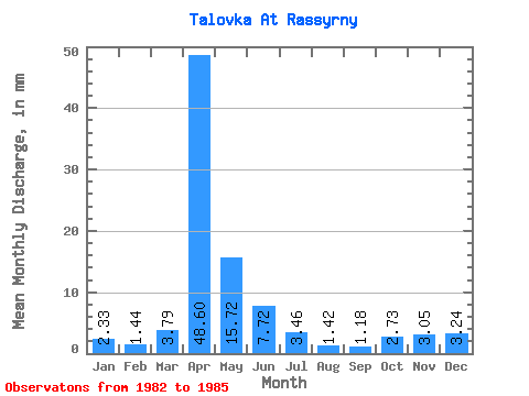
| Statistic | Jan | Feb | Mar | Apr | May | Jun | Jul | Aug | Sep | Oct | Nov | Dec | Annual |
|---|---|---|---|---|---|---|---|---|---|---|---|---|---|
| Mean | 2.33 | 1.45 | 3.78 | 48.61 | 15.72 | 7.72 | 3.46 | 1.42 | 1.18 | 2.73 | 3.05 | 3.24 | 96.75 |
| Standard Deviation | 0.50 | 1.01 | 1.13 | 28.03 | 4.32 | 4.26 | 0.31 | 0.62 | 0.53 | 1.81 | 1.58 | 1.37 | 29.72 |
| Min | 1.77 | 0.32 | 2.48 | 25.15 | 11.88 | 4.81 | 3.10 | 0.52 | 0.57 | 1.51 | 2.06 | 1.95 | 79.07 |
| Max | 2.75 | 2.26 | 4.52 | 79.65 | 20.39 | 12.62 | 3.64 | 1.95 | 1.81 | 5.41 | 5.41 | 5.14 | 131.07 |
| Coefficient of Variation | 0.22 | 0.69 | 0.30 | 0.58 | 0.27 | 0.55 | 0.09 | 0.44 | 0.45 | 0.66 | 0.52 | 0.42 | 0.31 |
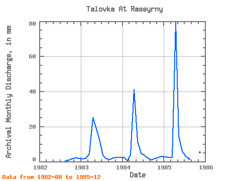
| Year | Jan | Feb | Mar | Apr | May | Jun | Jul | Aug | Sep | Oct | Nov | Dec | Annual | 1982 | 0.52 | 0.57 | 1.51 | 2.06 | 1.95 | 1983 | 1.77 | 1.78 | 4.52 | 25.15 | 20.39 | 12.62 | 3.64 | 1.69 | 1.37 | 2.13 | 2.32 | 2.66 | 80.12 | 1984 | 2.48 | 0.32 | 4.34 | 41.03 | 11.88 | 4.81 | 3.64 | 1.95 | 0.94 | 1.86 | 2.40 | 3.19 | 79.07 | 1985 | 2.75 | 2.26 | 2.48 | 79.65 | 14.90 | 5.75 | 3.10 | 1.51 | 1.81 | 5.41 | 5.41 | 5.14 | 131.07 |
|---|
 Return to R-Arctic Net Home Page