|
|
|||||||||||||||||
| Point ID: 8705 | Downloads | Plots | Site Data | Code: 11669 |
|
|
|||||||||||||||||
| Download | |
|---|---|
| Site Descriptor Information | Site Time Series Data |
| Link to all available data | |
|
|
| View: | Statistics | Time Series |
| Units: | m3/s |
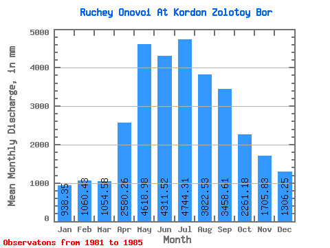
| Statistic | Jan | Feb | Mar | Apr | May | Jun | Jul | Aug | Sep | Oct | Nov | Dec | Annual |
|---|---|---|---|---|---|---|---|---|---|---|---|---|---|
| Mean | 938.21 | 1069.55 | 1054.42 | 2580.26 | 4618.29 | 4311.52 | 4743.60 | 3821.96 | 3458.61 | 2260.84 | 1705.83 | 1306.06 | 31793.23 |
| Standard Deviation | 236.40 | 724.02 | 482.63 | 581.77 | 1179.05 | 1419.43 | 640.44 | 902.25 | 607.75 | 876.29 | 268.10 | 749.72 | 2635.17 |
| Min | 581.08 | 521.15 | 436.56 | 1750.82 | 2647.68 | 2660.47 | 3850.26 | 2758.84 | 2621.34 | 743.78 | 1486.73 | 444.65 | 28870.45 |
| Max | 1232.89 | 2274.26 | 1637.12 | 3315.80 | 5790.54 | 5682.84 | 5659.17 | 5224.63 | 4225.45 | 2960.96 | 2171.41 | 2061.55 | 35075.27 |
| Coefficient of Variation | 0.25 | 0.68 | 0.46 | 0.23 | 0.26 | 0.33 | 0.14 | 0.24 | 0.18 | 0.39 | 0.16 | 0.57 | 0.08 |
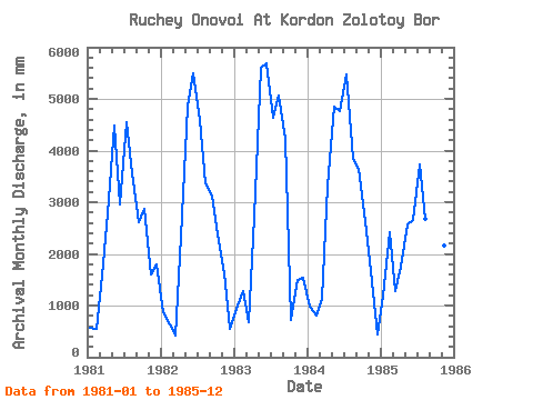
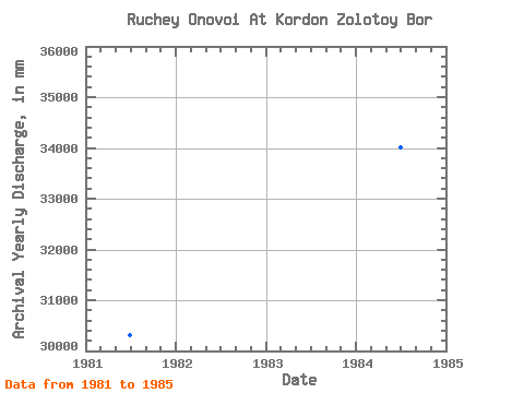
| Year | Jan | Feb | Mar | Apr | May | Jun | Jul | Aug | Sep | Oct | Nov | Dec | Annual | 1981 | 581.08 | 521.15 | 1637.12 | 2777.84 | 4638.50 | 2953.90 | 4689.03 | 3668.36 | 2621.34 | 2960.96 | 1594.32 | 1859.44 | 30330.35 | 1982 | 895.36 | 596.65 | 436.56 | 2327.91 | 5002.30 | 5497.00 | 4739.56 | 3486.45 | 3129.96 | 2445.57 | 1613.89 | 567.94 | 30654.88 | 1983 | 961.05 | 1206.19 | 702.34 | 2728.94 | 5790.54 | 5682.84 | 4779.98 | 5224.63 | 4225.45 | 743.78 | 1486.73 | 1596.69 | 35075.27 | 1984 | 1020.67 | 749.49 | 1172.26 | 3315.80 | 5012.41 | 4763.41 | 5659.17 | 3971.52 | 3638.58 | 2728.53 | 1662.79 | 444.65 | 34035.18 | 1985 | 1232.89 | 2274.26 | 1323.84 | 1750.82 | 2647.68 | 2660.47 | 3850.26 | 2758.84 | 3677.71 | 2425.36 | 2171.41 | 2061.55 | 28870.45 |
|---|
 Return to R-Arctic Net Home Page