|
|
|||||||||||||||||
| Point ID: 87 | Downloads | Plots | Site Data | Code: 05AD006 |
|
|
|||||||||||||||||
| Download | |
|---|---|
| Site Descriptor Information | Site Time Series Data |
| Link to all available data | |
|
|
| View: | Statistics | Time Series |
| Units: | m3/s |
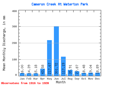
| Statistic | Jan | Feb | Mar | Apr | May | Jun | Jul | Aug | Sep | Oct | Nov | Dec | Annual |
|---|---|---|---|---|---|---|---|---|---|---|---|---|---|
| Mean | 15.98 | 14.51 | 15.19 | 43.58 | 217.64 | 301.73 | 117.16 | 35.90 | 27.86 | 18.49 | 19.02 | 18.89 | 848.05 |
| Standard Deviation | 6.57 | 5.30 | 6.88 | 23.58 | 84.79 | 142.31 | 78.90 | 16.02 | 19.77 | 5.76 | 7.24 | 11.32 | 263.38 |
| Min | 11.81 | 10.76 | 9.70 | 13.24 | 151.10 | 134.39 | 44.24 | 17.97 | 9.88 | 11.44 | 14.99 | 11.40 | 551.67 |
| Max | 27.43 | 23.81 | 26.68 | 62.91 | 340.32 | 421.62 | 211.68 | 56.83 | 55.01 | 24.67 | 29.88 | 35.39 | 1075.16 |
| Coefficient of Variation | 0.41 | 0.36 | 0.45 | 0.54 | 0.39 | 0.47 | 0.67 | 0.45 | 0.71 | 0.31 | 0.38 | 0.60 | 0.31 |
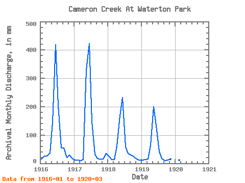
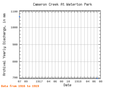
| Year | Jan | Feb | Mar | Apr | May | Jun | Jul | Aug | Sep | Oct | Nov | Dec | Annual | 1916 | 15.62 | 23.81 | 26.68 | 36.56 | 151.10 | 418.33 | 211.68 | 56.83 | 55.01 | 21.27 | 29.88 | 17.15 | 1064.73 | 1917 | 12.56 | 10.76 | 10.04 | 13.24 | 340.32 | 421.62 | 152.12 | 32.70 | 17.33 | 16.57 | 15.55 | 35.39 | 1075.16 | 1918 | 27.43 | 13.36 | 14.53 | 61.60 | 173.56 | 232.55 | 60.58 | 36.07 | 29.22 | 24.67 | 15.68 | 11.61 | 700.63 | 1919 | 12.49 | 12.84 | 15.01 | 62.91 | 205.56 | 134.39 | 44.24 | 17.97 | 9.88 | 11.44 | 14.99 | 11.40 | 551.67 | 1920 | 11.81 | 11.75 | 9.70 |
|---|
 Return to R-Arctic Net Home Page