|
|
|||||||||||||||||
| Point ID: 8660 | Downloads | Plots | Site Data | Code: 11489 |
|
|
|||||||||||||||||
| Download | |
|---|---|
| Site Descriptor Information | Site Time Series Data |
| Link to all available data | |
|
|
| View: | Statistics | Time Series |
| Units: | m3/s |
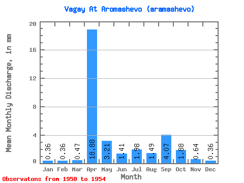
| Statistic | Jan | Feb | Mar | Apr | May | Jun | Jul | Aug | Sep | Oct | Nov | Dec | Annual |
|---|---|---|---|---|---|---|---|---|---|---|---|---|---|
| Mean | 0.36 | 0.36 | 0.47 | 18.88 | 3.21 | 1.41 | 1.98 | 1.48 | 4.07 | 1.88 | 0.64 | 0.36 | 44.37 |
| Standard Deviation | 0.13 | 0.04 | 0.10 | 13.61 | 3.18 | 1.33 | 1.49 | 1.26 | 4.76 | 1.88 | 0.51 | 0.12 | 29.62 |
| Min | 0.23 | 0.31 | 0.41 | 8.17 | 1.02 | 0.09 | 0.93 | 0.59 | 0.71 | 0.55 | 0.28 | 0.28 | 23.42 |
| Max | 0.49 | 0.39 | 0.59 | 34.20 | 8.73 | 3.22 | 3.04 | 2.38 | 7.43 | 3.21 | 0.99 | 0.45 | 65.31 |
| Coefficient of Variation | 0.36 | 0.12 | 0.21 | 0.72 | 0.99 | 0.94 | 0.75 | 0.85 | 1.17 | 1.00 | 0.79 | 0.34 | 0.67 |
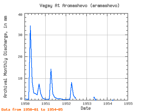
| Year | Jan | Feb | Mar | Apr | May | Jun | Jul | Aug | Sep | Oct | Nov | Dec | Annual | 1950 | 0.49 | 0.38 | 0.41 | 34.20 | 8.73 | 3.22 | 3.04 | 2.38 | 7.43 | 3.21 | 0.99 | 0.45 | 65.31 | 1951 | 0.37 | 0.31 | 0.59 | 14.27 | 2.95 | 1.43 | 0.93 | 0.59 | 0.71 | 0.55 | 0.28 | 0.28 | 23.42 | 1952 | 0.23 | 0.39 | 0.42 | 8.17 | 2.08 | 0.92 | 1953 | 1.28 | 0.09 | 1954 | 1.02 |
|---|
 Return to R-Arctic Net Home Page