|
|
|||||||||||||||||
| Point ID: 8617 | Downloads | Plots | Site Data | Code: 11243 |
|
|
|||||||||||||||||
| Download | |
|---|---|
| Site Descriptor Information | Site Time Series Data |
| Link to all available data | |
|
|
| View: | Statistics | Time Series |
| Units: | m3/s |
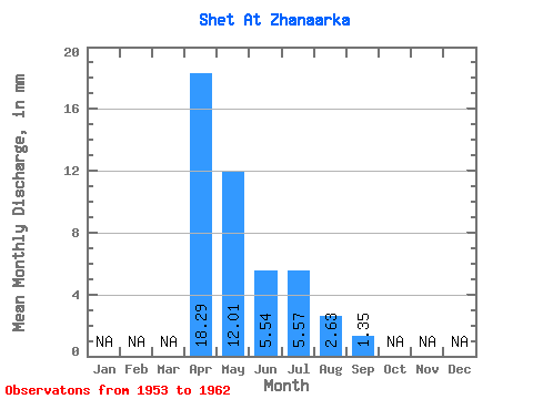
| Statistic | Jan | Feb | Mar | Apr | May | Jun | Jul | Aug | Sep | Oct | Nov | Dec | Annual |
|---|---|---|---|---|---|---|---|---|---|---|---|---|---|
| Mean | 18.29 | 12.01 | 5.54 | 5.57 | 2.63 | 1.35 | |||||||
| Standard Deviation | 5.57 | 6.87 | 4.84 | 3.14 | 1.41 | 0.22 | |||||||
| Min | 14.36 | 2.58 | 0.39 | 2.27 | 1.34 | 1.20 | |||||||
| Max | 22.23 | 21.53 | 13.27 | 9.79 | 4.54 | 1.50 | |||||||
| Coefficient of Variation | 0.30 | 0.57 | 0.87 | 0.56 | 0.54 | 0.16 |
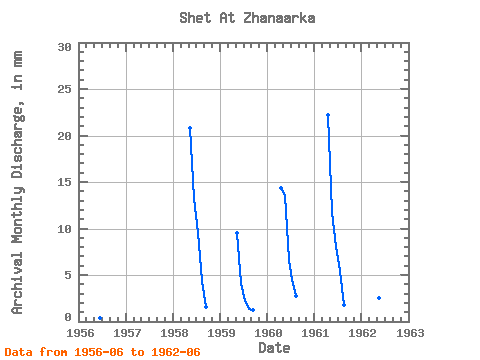
| Year | Jan | Feb | Mar | Apr | May | Jun | Jul | Aug | Sep | Oct | Nov | Dec | Annual | 1953 | 1956 | 0.39 | 1958 | 21.53 | 13.27 | 9.79 | 4.54 | 1.50 | 1959 | 9.79 | 4.19 | 2.27 | 1.34 | 1.20 | 1960 | 14.36 | 14.01 | 6.58 | 4.64 | 2.79 | 1961 | 22.23 | 12.15 | 7.97 | 5.56 | 1.85 | 1962 | 2.58 | 0.86 |
|---|
 Return to R-Arctic Net Home Page