|
|
|||||||||||||||||
| Point ID: 8595 | Downloads | Plots | Site Data | Code: 11184 |
|
|
|||||||||||||||||
| Download | |
|---|---|
| Site Descriptor Information | Site Time Series Data |
| Link to all available data | |
|
|
| View: | Statistics | Time Series |
| Units: | m3/s |
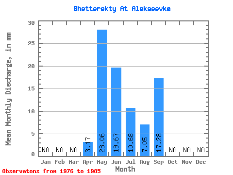
| Statistic | Jan | Feb | Mar | Apr | May | Jun | Jul | Aug | Sep | Oct | Nov | Dec | Annual |
|---|---|---|---|---|---|---|---|---|---|---|---|---|---|
| Mean | 3.17 | 28.06 | 19.67 | 10.68 | 7.06 | 17.28 | |||||||
| Standard Deviation | 21.29 | 14.29 | 6.18 | 3.19 | |||||||||
| Min | 3.17 | 8.33 | 1.73 | 2.08 | 1.79 | 17.28 | |||||||
| Max | 3.17 | 73.20 | 41.47 | 20.53 | 12.20 | 17.28 | |||||||
| Coefficient of Variation | 0.76 | 0.73 | 0.58 | 0.45 |
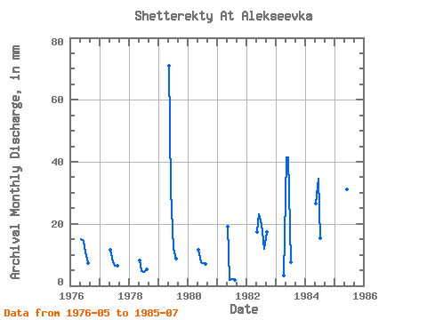
| Year | Jan | Feb | Mar | Apr | May | Jun | Jul | Aug | Sep | Oct | Nov | Dec | Annual | 1976 | 15.47 | 14.40 | 11.01 | 7.44 | 1977 | 11.90 | 7.49 | 6.55 | 6.55 | 1978 | 8.33 | 4.61 | 4.46 | 5.36 | 1979 | 73.20 | 30.82 | 12.20 | 8.93 | 1980 | 11.90 | 7.49 | 7.44 | 7.14 | 1981 | 19.64 | 1.73 | 2.08 | 1.79 | 1982 | 17.85 | 23.04 | 20.53 | 12.20 | 17.28 | 1983 | 3.17 | 42.85 | 41.47 | 7.74 | 1984 | 27.38 | 34.56 | 15.77 | 1985 | 52.07 | 31.10 | 19.04 |
|---|
 Return to R-Arctic Net Home Page