|
|
|||||||||||||||||
| Point ID: 8591 | Downloads | Plots | Site Data | Code: 11179 |
|
|
|||||||||||||||||
| Download | |
|---|---|
| Site Descriptor Information | Site Time Series Data |
| Link to all available data | |
|
|
| View: | Statistics | Time Series |
| Units: | m3/s |
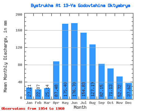
| Statistic | Jan | Feb | Mar | Apr | May | Jun | Jul | Aug | Sep | Oct | Nov | Dec | Annual |
|---|---|---|---|---|---|---|---|---|---|---|---|---|---|
| Mean | 27.21 | 23.07 | 25.14 | 87.48 | 175.39 | 176.69 | 154.81 | 127.16 | 82.14 | 71.11 | 52.73 | 37.61 | 1105.36 |
| Standard Deviation | 3.48 | 2.33 | 2.37 | 34.73 | 52.17 | 55.46 | 62.76 | 52.37 | 15.56 | 18.16 | 11.80 | 7.88 | 200.21 |
| Min | 22.54 | 19.41 | 21.93 | 50.96 | 136.64 | 77.17 | 59.65 | 46.26 | 55.67 | 46.56 | 33.89 | 29.52 | 930.36 |
| Max | 31.65 | 25.23 | 28.61 | 142.26 | 271.76 | 235.64 | 251.37 | 200.85 | 105.15 | 93.43 | 63.92 | 47.78 | 1322.17 |
| Coefficient of Variation | 0.13 | 0.10 | 0.09 | 0.40 | 0.30 | 0.31 | 0.41 | 0.41 | 0.19 | 0.26 | 0.22 | 0.21 | 0.18 |
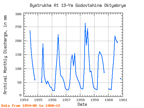
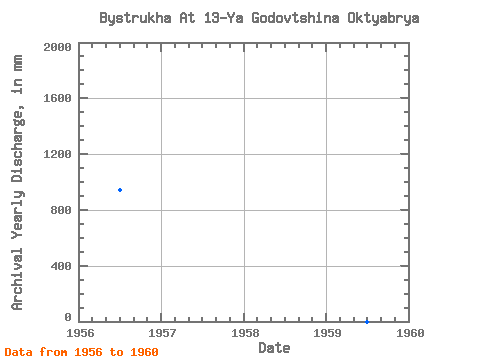
| Year | Jan | Feb | Mar | Apr | May | Jun | Jul | Aug | Sep | Oct | Nov | Dec | Annual | 1954 | 235.64 | 167.38 | 123.25 | 88.95 | 61.17 | 1955 | 51.56 | 195.37 | 77.17 | 59.65 | 46.26 | 55.67 | 46.56 | 33.89 | 33.48 | 1956 | 22.54 | 19.41 | 21.93 | 86.30 | 143.94 | 222.09 | 132.68 | 76.69 | 71.58 | 64.82 | 49.48 | 29.52 | 939.96 | 1957 | 25.26 | 22.18 | 24.95 | 50.96 | 136.64 | 149.34 | 112.60 | 159.77 | 78.94 | 69.39 | 56.26 | 47.78 | 930.36 | 1958 | 31.65 | 24.40 | 28.61 | 107.51 | 271.76 | 183.21 | 251.37 | 156.42 | 87.78 | 93.43 | 60.09 | 33.17 | 1322.17 | 1959 | 28.91 | 24.12 | 25.26 | 142.26 | 165.85 | 152.28 | 152.16 | 126.90 | 86.89 | 1960 | 27.69 | 25.23 | 24.95 | 86.30 | 138.77 | 217.08 | 207.85 | 200.85 | 105.15 | 91.30 | 63.92 | 44.13 | 1228.93 |
|---|
 Return to R-Arctic Net Home Page