|
|
|||||||||||||||||
| Point ID: 859 | Downloads | Plots | Site Data | Code: 07EB002 |
|
|
|||||||||||||||||
| Download | |
|---|---|
| Site Descriptor Information | Site Time Series Data |
| Link to all available data | |
|
|
| View: | Statistics | Time Series |
| Units: | m3/s |
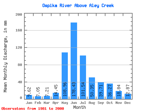
| Statistic | Jan | Feb | Mar | Apr | May | Jun | Jul | Aug | Sep | Oct | Nov | Dec | Annual |
|---|---|---|---|---|---|---|---|---|---|---|---|---|---|
| Mean | 9.62 | 7.11 | 7.21 | 14.45 | 108.94 | 178.43 | 101.52 | 50.34 | 39.71 | 36.26 | 18.84 | 12.87 | 583.69 |
| Standard Deviation | 1.85 | 1.10 | 1.22 | 5.71 | 43.38 | 45.06 | 32.62 | 13.98 | 14.21 | 14.66 | 5.84 | 3.29 | 71.91 |
| Min | 6.21 | 4.02 | 3.63 | 6.78 | 45.24 | 90.49 | 56.34 | 28.23 | 20.67 | 11.87 | 7.71 | 6.80 | 467.01 |
| Max | 13.15 | 8.84 | 9.77 | 30.24 | 191.80 | 245.19 | 191.80 | 74.19 | 67.84 | 74.07 | 33.86 | 18.94 | 705.92 |
| Coefficient of Variation | 0.19 | 0.15 | 0.17 | 0.40 | 0.40 | 0.25 | 0.32 | 0.28 | 0.36 | 0.40 | 0.31 | 0.26 | 0.12 |
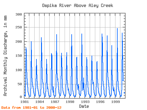
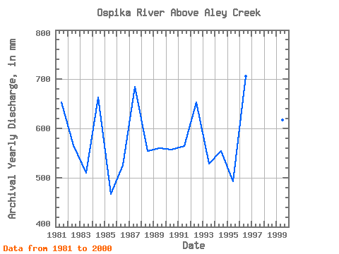
| Year | Jan | Feb | Mar | Apr | May | Jun | Jul | Aug | Sep | Oct | Nov | Dec | Annual | 1981 | 13.15 | 8.29 | 7.83 | 7.50 | 183.36 | 164.63 | 106.16 | 59.23 | 52.42 | 25.33 | 16.00 | 12.18 | 652.94 | 1982 | 8.53 | 6.65 | 7.13 | 6.78 | 61.88 | 199.65 | 83.23 | 64.17 | 40.28 | 43.31 | 27.79 | 17.37 | 566.21 | 1983 | 12.30 | 8.80 | 7.61 | 16.70 | 88.78 | 136.60 | 98.19 | 47.77 | 35.73 | 30.04 | 18.91 | 10.66 | 510.55 | 1984 | 8.91 | 6.64 | 7.07 | 12.14 | 51.87 | 213.66 | 147.17 | 74.19 | 51.72 | 54.89 | 20.20 | 16.04 | 662.94 | 1985 | 9.86 | 6.74 | 6.39 | 8.26 | 73.10 | 136.60 | 106.28 | 33.41 | 40.75 | 26.90 | 11.91 | 8.13 | 467.01 | 1986 | 8.67 | 6.68 | 6.49 | 7.02 | 54.77 | 157.62 | 153.20 | 50.54 | 20.67 | 41.98 | 12.96 | 8.18 | 526.40 | 1987 | 7.06 | 6.18 | 7.36 | 11.12 | 111.46 | 224.17 | 97.95 | 65.62 | 67.84 | 46.68 | 23.70 | 16.89 | 684.97 | 1988 | 11.47 | 8.42 | 8.36 | 19.73 | 141.14 | 158.79 | 96.62 | 42.34 | 22.18 | 23.16 | 14.48 | 10.64 | 555.17 | 1989 | 9.41 | 7.56 | 7.38 | 20.78 | 135.11 | 161.12 | 70.45 | 50.54 | 28.84 | 34.86 | 21.02 | 14.84 | 560.12 | 1990 | 12.55 | 7.77 | 9.01 | 15.88 | 142.34 | 224.17 | 68.04 | 31.12 | 20.78 | 11.87 | 7.71 | 6.80 | 557.54 | 1991 | 6.21 | 7.19 | 6.55 | 17.28 | 145.96 | 144.78 | 83.48 | 31.24 | 40.75 | 50.91 | 18.45 | 13.87 | 564.41 | 1992 | 12.18 | 8.84 | 9.77 | 30.24 | 94.69 | 226.51 | 77.69 | 28.23 | 39.00 | 74.07 | 33.86 | 18.94 | 653.88 | 1993 | 8.41 | 6.81 | 7.36 | 17.16 | 148.38 | 129.60 | 95.54 | 49.46 | 27.91 | 17.73 | 13.54 | 10.02 | 529.17 | 1994 | 8.48 | 4.02 | 3.63 | 13.19 | 118.46 | 149.45 | 77.56 | 52.72 | 56.63 | 36.79 | 20.90 | 13.87 | 553.96 | 1995 | 10.23 | 8.15 | 7.95 | 13.31 | 126.66 | 129.60 | 77.20 | 46.56 | 27.79 | 21.71 | 14.83 | 11.10 | 493.05 | 1996 | 8.70 | 6.50 | 6.60 | 17.05 | 69.84 | 226.51 | 191.80 | 68.16 | 43.43 | 41.50 | 17.16 | 10.83 | 705.92 | 1997 | 8.55 | 6.81 | 6.44 | 9.76 | 119.30 | 219.50 | 107.24 | 65.98 | 63.16 | 48.73 | 23.35 | 14.23 | 691.61 | 1998 | 9.37 | 7.08 | 7.51 | 14.24 | 191.80 | 90.49 | 56.34 | 34.26 | 25.69 | 38.60 | 19.85 | 13.27 | 504.96 | 1999 | 8.99 | 6.64 | 7.25 | 19.27 | 74.67 | 245.19 | 112.07 | 46.56 | 34.21 | 26.06 | 21.13 | 15.08 | 617.10 | 2000 | 9.26 | 6.41 | 6.53 | 11.55 | 45.24 | 230.01 | 124.25 | 64.66 | 54.41 | 30.16 | 19.03 | 14.48 | 615.81 |
|---|
 Return to R-Arctic Net Home Page