|
|
|||||||||||||||||
| Point ID: 8540 | Downloads | Plots | Site Data | Code: 10703 |
|
|
|||||||||||||||||
| Download | |
|---|---|
| Site Descriptor Information | Site Time Series Data |
| Link to all available data | |
|
|
| View: | Statistics | Time Series |
| Units: | m3/s |
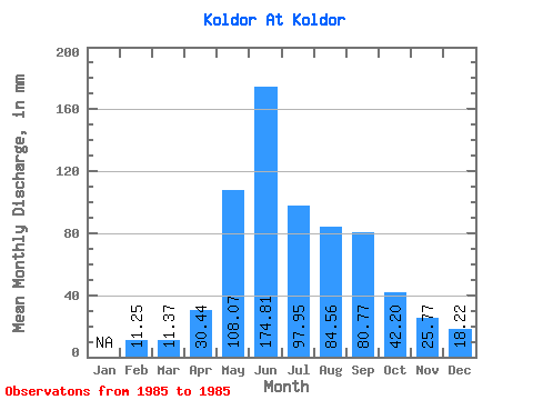
| Statistic | Jan | Feb | Mar | Apr | May | Jun | Jul | Aug | Sep | Oct | Nov | Dec | Annual |
|---|---|---|---|---|---|---|---|---|---|---|---|---|---|
| Mean | 11.35 | 11.37 | 30.44 | 108.05 | 174.81 | 97.93 | 84.54 | 80.77 | 42.19 | 25.77 | 18.22 | ||
| Standard Deviation | |||||||||||||
| Min | 11.35 | 11.37 | 30.44 | 108.05 | 174.81 | 97.93 | 84.54 | 80.77 | 42.19 | 25.77 | 18.22 | ||
| Max | 11.35 | 11.37 | 30.44 | 108.05 | 174.81 | 97.93 | 84.54 | 80.77 | 42.19 | 25.77 | 18.22 | ||
| Coefficient of Variation |
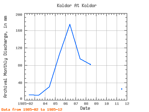
| Year | Jan | Feb | Mar | Apr | May | Jun | Jul | Aug | Sep | Oct | Nov | Dec | Annual | 1985 | 11.35 | 11.37 | 30.44 | 108.05 | 174.81 | 97.93 | 84.54 | 80.77 | 42.19 | 25.77 | 18.22 |
|---|
 Return to R-Arctic Net Home Page