|
|
|||||||||||||||||
| Point ID: 8537 | Downloads | Plots | Site Data | Code: 10695 |
|
|
|||||||||||||||||
| Download | |
|---|---|
| Site Descriptor Information | Site Time Series Data |
| Link to all available data | |
|
|
| View: | Statistics | Time Series |
| Units: | m3/s |
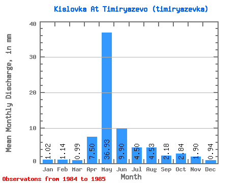
| Statistic | Jan | Feb | Mar | Apr | May | Jun | Jul | Aug | Sep | Oct | Nov | Dec | Annual |
|---|---|---|---|---|---|---|---|---|---|---|---|---|---|
| Mean | 1.02 | 1.15 | 0.99 | 7.50 | 36.92 | 9.90 | 4.50 | 4.53 | 2.18 | 2.84 | 1.90 | 0.94 | 73.85 |
| Standard Deviation | 0.04 | 0.11 | 0.25 | 7.32 | 19.47 | 0.40 | 0.66 | 4.09 | 1.48 | 0.54 | 0.52 | 0.25 | 31.35 |
| Min | 0.99 | 1.07 | 0.82 | 2.32 | 23.16 | 9.62 | 4.04 | 1.64 | 1.13 | 2.46 | 1.53 | 0.76 | 51.68 |
| Max | 1.05 | 1.23 | 1.17 | 12.68 | 50.70 | 10.19 | 4.97 | 7.43 | 3.23 | 3.22 | 2.26 | 1.11 | 96.01 |
| Coefficient of Variation | 0.04 | 0.10 | 0.25 | 0.98 | 0.53 | 0.04 | 0.15 | 0.90 | 0.68 | 0.19 | 0.27 | 0.27 | 0.42 |
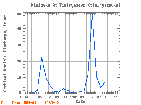
| Year | Jan | Feb | Mar | Apr | May | Jun | Jul | Aug | Sep | Oct | Nov | Dec | Annual | 1984 | 1.05 | 1.07 | 0.82 | 2.32 | 23.16 | 9.62 | 4.97 | 1.64 | 1.13 | 3.22 | 2.26 | 0.76 | 51.68 | 1985 | 0.99 | 1.23 | 1.17 | 12.68 | 50.70 | 10.19 | 4.04 | 7.43 | 3.23 | 2.46 | 1.53 | 1.11 | 96.01 |
|---|
 Return to R-Arctic Net Home Page