|
|
|||||||||||||||||
| Point ID: 8534 | Downloads | Plots | Site Data | Code: 10688 |
|
|
|||||||||||||||||
| Download | |
|---|---|
| Site Descriptor Information | Site Time Series Data |
| Link to all available data | |
|
|
| View: | Statistics | Time Series |
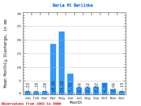
| Units: | m3/s |
| Statistic | Jan | Feb | Mar | Apr | May | Jun | Jul | Aug | Sep | Oct | Nov | Dec | Annual |
|---|---|---|---|---|---|---|---|---|---|---|---|---|---|
| Mean | 1.23 | 1.19 | 1.29 | 18.55 | 23.02 | 7.72 | 2.66 | 2.62 | 2.83 | 4.31 | 2.06 | 1.20 | 68.57 |
| Standard Deviation | 0.48 | 0.63 | 0.95 | 21.43 | 12.50 | 3.96 | 0.80 | 0.83 | 1.01 | 0.96 | 0.58 | 0.47 | 27.24 |
| Min | 0.79 | 0.57 | 0.40 | 2.66 | 12.66 | 2.48 | 1.47 | 1.67 | 1.56 | 3.48 | 1.30 | 0.68 | 33.40 |
| Max | 1.83 | 2.00 | 2.57 | 48.64 | 40.90 | 12.07 | 3.12 | 3.48 | 3.73 | 5.69 | 2.66 | 1.76 | 99.67 |
| Coefficient of Variation | 0.39 | 0.53 | 0.74 | 1.16 | 0.54 | 0.51 | 0.30 | 0.32 | 0.36 | 0.22 | 0.28 | 0.39 | 0.40 |
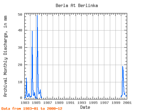
| Year | Jan | Feb | Mar | Apr | May | Jun | Jul | Aug | Sep | Oct | Nov | Dec | Annual | 1983 | 0.92 | 0.84 | 0.75 | 3.73 | 12.66 | 2.48 | 1.47 | 1.67 | 1.56 | 3.48 | 2.66 | 1.36 | 33.40 | 1984 | 1.38 | 1.35 | 1.43 | 2.66 | 40.90 | 12.07 | 3.12 | 2.20 | 2.48 | 4.22 | 1.30 | 0.68 | 73.21 | 1985 | 0.79 | 0.57 | 0.40 | 48.64 | 21.83 | 7.81 | 3.12 | 3.48 | 3.73 | 5.69 | 2.31 | 0.99 | 99.67 | 2000 | 1.83 | 2.00 | 2.57 | 19.17 | 16.69 | 8.52 | 2.94 | 3.12 | 3.55 | 3.85 | 1.95 | 1.76 | 68.02 |
|---|
 Return to R-Arctic Net Home Page