|
|
|||||||||||||||||
| Point ID: 8532 | Downloads | Plots | Site Data | Code: 10660 |
|
|
|||||||||||||||||
| Download | |
|---|---|
| Site Descriptor Information | Site Time Series Data |
| Link to all available data | |
|
|
| View: | Statistics | Time Series |
| Units: | m3/s |
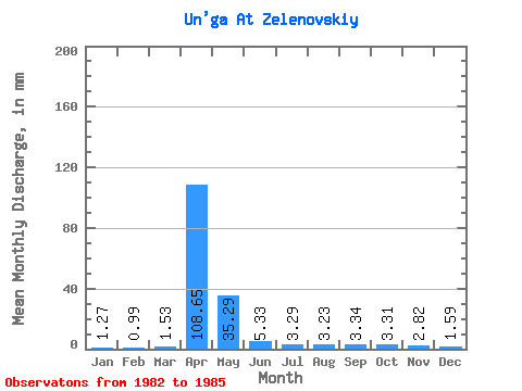
| Statistic | Jan | Feb | Mar | Apr | May | Jun | Jul | Aug | Sep | Oct | Nov | Dec | Annual |
|---|---|---|---|---|---|---|---|---|---|---|---|---|---|
| Mean | 1.27 | 1.00 | 1.53 | 108.65 | 35.29 | 5.33 | 3.29 | 3.23 | 3.34 | 3.31 | 2.82 | 1.59 | 171.60 |
| Standard Deviation | 0.42 | 0.35 | 0.61 | 38.00 | 28.90 | 2.90 | 1.77 | 1.77 | 1.69 | 2.35 | 1.37 | 0.22 | 49.43 |
| Min | 0.71 | 0.64 | 0.87 | 61.56 | 6.18 | 1.69 | 1.34 | 1.70 | 2.09 | 1.70 | 1.58 | 1.31 | 127.15 |
| Max | 1.72 | 1.48 | 2.12 | 154.64 | 72.58 | 8.09 | 5.40 | 5.68 | 5.80 | 6.74 | 4.59 | 1.86 | 217.47 |
| Coefficient of Variation | 0.33 | 0.36 | 0.40 | 0.35 | 0.82 | 0.54 | 0.54 | 0.55 | 0.51 | 0.71 | 0.49 | 0.14 | 0.29 |
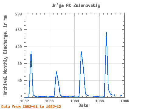
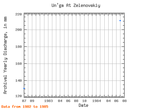
| Year | Jan | Feb | Mar | Apr | May | Jun | Jul | Aug | Sep | Oct | Nov | Dec | Annual | 1982 | 0.71 | 0.64 | 0.87 | 109.28 | 6.18 | 1.69 | 1.34 | 1.70 | 2.09 | 1.70 | 1.58 | 1.31 | 130.57 | 1983 | 1.72 | 1.48 | 2.12 | 61.56 | 42.00 | 4.36 | 2.45 | 2.18 | 2.44 | 1.90 | 3.17 | 1.58 | 127.15 | 1984 | 1.39 | 0.98 | 1.98 | 109.13 | 72.58 | 8.09 | 3.99 | 3.36 | 3.00 | 2.88 | 1.93 | 1.60 | 211.19 | 1985 | 1.28 | 0.89 | 1.17 | 154.64 | 20.39 | 7.20 | 5.40 | 5.68 | 5.80 | 6.74 | 4.59 | 1.86 | 217.47 |
|---|
 Return to R-Arctic Net Home Page