|
|
|||||||||||||||||
| Point ID: 8498 | Downloads | Plots | Site Data | Code: 10410 |
|
|
|||||||||||||||||
| Download | |
|---|---|
| Site Descriptor Information | Site Time Series Data |
| Link to all available data | |
|
|
| View: | Statistics | Time Series |
| Units: | m3/s |
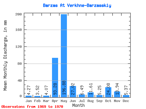
| Statistic | Jan | Feb | Mar | Apr | May | Jun | Jul | Aug | Sep | Oct | Nov | Dec | Annual |
|---|---|---|---|---|---|---|---|---|---|---|---|---|---|
| Mean | 4.27 | 3.55 | 4.07 | 93.28 | 196.85 | 27.02 | 6.49 | 11.61 | 5.25 | 24.08 | 13.94 | 5.37 | 393.56 |
| Standard Deviation | 1.15 | 0.19 | 0.61 | 94.03 | 277.21 | 9.25 | 1.99 | 2.04 | 1.85 | 14.88 | 2.69 | 1.12 | 200.71 |
| Min | 3.46 | 3.42 | 3.64 | 26.79 | 0.83 | 20.48 | 5.08 | 10.16 | 3.94 | 13.55 | 12.04 | 4.58 | 251.64 |
| Max | 5.08 | 3.68 | 4.50 | 159.78 | 392.87 | 33.56 | 7.89 | 13.05 | 6.56 | 34.60 | 15.84 | 6.16 | 535.49 |
| Coefficient of Variation | 0.27 | 0.05 | 0.15 | 1.01 | 1.41 | 0.34 | 0.31 | 0.18 | 0.35 | 0.62 | 0.19 | 0.21 | 0.51 |
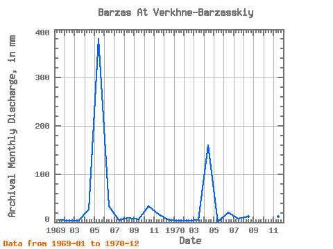
| Year | Jan | Feb | Mar | Apr | May | Jun | Jul | Aug | Sep | Oct | Nov | Dec | Annual | 1969 | 5.08 | 3.42 | 3.64 | 26.79 | 392.87 | 33.56 | 5.08 | 10.16 | 6.56 | 34.60 | 15.84 | 4.58 | 535.49 | 1970 | 3.46 | 3.68 | 4.50 | 159.78 | 0.83 | 20.48 | 7.89 | 13.05 | 3.94 | 13.55 | 12.04 | 6.16 | 251.64 |
|---|
 Return to R-Arctic Net Home Page