|
|
|||||||||||||||||
| Point ID: 8473 | Downloads | Plots | Site Data | Code: 10304 |
|
|
|||||||||||||||||
| Download | |
|---|---|
| Site Descriptor Information | Site Time Series Data |
| Link to all available data | |
|
|
| View: | Statistics | Time Series |
| Units: | m3/s |
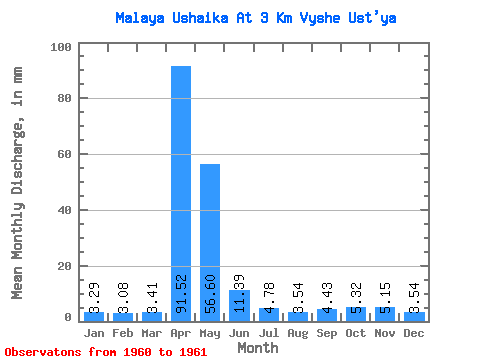
| Statistic | Jan | Feb | Mar | Apr | May | Jun | Jul | Aug | Sep | Oct | Nov | Dec | Annual |
|---|---|---|---|---|---|---|---|---|---|---|---|---|---|
| Mean | 3.29 | 3.11 | 3.41 | 91.53 | 56.60 | 11.39 | 4.78 | 3.54 | 4.43 | 5.32 | 5.15 | 3.54 | 196.51 |
| Standard Deviation | 0.18 | 0.75 | 0.94 | 36.77 | 49.34 | 4.38 | 2.53 | 1.00 | 0.00 | 0.47 | 1.02 | 0.41 | 16.06 |
| Min | 3.16 | 2.58 | 2.75 | 65.52 | 21.71 | 8.29 | 2.99 | 2.83 | 4.43 | 4.99 | 4.43 | 3.24 | 185.16 |
| Max | 3.41 | 3.64 | 4.08 | 117.53 | 91.48 | 14.49 | 6.57 | 4.24 | 4.43 | 5.66 | 5.88 | 3.83 | 207.87 |
| Coefficient of Variation | 0.05 | 0.24 | 0.28 | 0.40 | 0.87 | 0.39 | 0.53 | 0.28 | 0.00 | 0.09 | 0.20 | 0.12 | 0.08 |
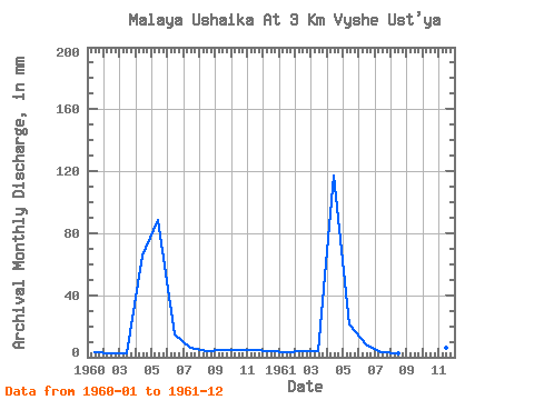
| Year | Jan | Feb | Mar | Apr | May | Jun | Jul | Aug | Sep | Oct | Nov | Dec | Annual | 1960 | 3.16 | 2.58 | 2.75 | 65.52 | 91.48 | 14.49 | 6.57 | 4.24 | 4.43 | 4.99 | 4.43 | 3.83 | 207.87 | 1961 | 3.41 | 3.64 | 4.08 | 117.53 | 21.71 | 8.29 | 2.99 | 2.83 | 4.43 | 5.66 | 5.88 | 3.24 | 185.16 |
|---|
 Return to R-Arctic Net Home Page