|
|
|||||||||||||||||
| Point ID: 8466 | Downloads | Plots | Site Data | Code: 10260 |
|
|
|||||||||||||||||
| Download | |
|---|---|
| Site Descriptor Information | Site Time Series Data |
| Link to all available data | |
|
|
| View: | Statistics | Time Series |
| Units: | m3/s |
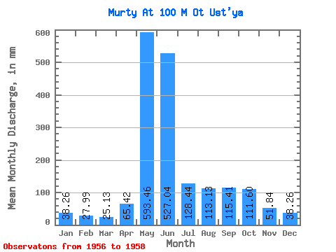
| Statistic | Jan | Feb | Mar | Apr | May | Jun | Jul | Aug | Sep | Oct | Nov | Dec | Annual |
|---|---|---|---|---|---|---|---|---|---|---|---|---|---|
| Mean | 38.26 | 28.27 | 25.08 | 65.42 | 593.41 | 527.04 | 128.37 | 113.07 | 115.41 | 111.58 | 51.84 | 38.26 | 1469.04 |
| Standard Deviation | 10.12 | 7.38 | 6.29 | 13.91 | 68.51 | 487.69 | 96.53 | 21.39 | 65.46 | 56.81 | 12.22 | 5.41 | 228.48 |
| Min | 26.78 | 19.75 | 17.85 | 56.78 | 516.47 | 229.58 | 68.86 | 99.47 | 69.12 | 71.41 | 43.20 | 34.43 | 1307.49 |
| Max | 45.91 | 32.53 | 29.33 | 81.46 | 647.82 | 1089.87 | 239.75 | 137.73 | 161.69 | 151.75 | 60.48 | 42.08 | 1630.60 |
| Coefficient of Variation | 0.27 | 0.26 | 0.25 | 0.21 | 0.12 | 0.93 | 0.75 | 0.19 | 0.57 | 0.51 | 0.24 | 0.14 | 0.16 |
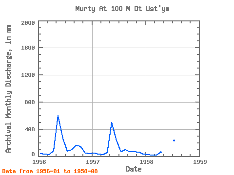
| Year | Jan | Feb | Mar | Apr | May | Jun | Jul | Aug | Sep | Oct | Nov | Dec | Annual | 1956 | 42.08 | 32.53 | 28.05 | 81.46 | 615.94 | 261.67 | 76.51 | 102.02 | 161.69 | 151.75 | 43.20 | 42.08 | 1630.60 | 1957 | 45.91 | 32.53 | 29.33 | 56.78 | 516.47 | 229.58 | 68.86 | 99.47 | 69.12 | 71.41 | 60.48 | 34.43 | 1307.49 | 1958 | 26.78 | 19.75 | 17.85 | 58.01 | 647.82 | 1089.87 | 239.75 | 137.73 |
|---|
 Return to R-Arctic Net Home Page