|
|
|||||||||||||||||
| Point ID: 8461 | Downloads | Plots | Site Data | Code: 10229 |
|
|
|||||||||||||||||
| Download | |
|---|---|
| Site Descriptor Information | Site Time Series Data |
| Link to all available data | |
|
|
| View: | Statistics | Time Series |
| Units: | m3/s |
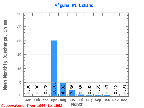
| Statistic | Jan | Feb | Mar | Apr | May | Jun | Jul | Aug | Sep | Oct | Nov | Dec | Annual |
|---|---|---|---|---|---|---|---|---|---|---|---|---|---|
| Mean | 0.00 | 0.00 | 0.28 | 20.01 | 4.81 | 2.36 | 0.65 | 0.34 | 0.55 | 0.47 | 0.13 | 0.02 | 26.31 |
| Standard Deviation | 0.00 | 0.00 | 0.48 | 2.66 | 2.69 | 2.32 | 0.56 | 0.42 | 0.45 | 0.40 | 0.13 | 0.03 | 5.54 |
| Min | 0.00 | 0.00 | 0.00 | 18.13 | 2.50 | 0.51 | 0.01 | 0.08 | 0.04 | 0.06 | 0.00 | 0.00 | 22.39 |
| Max | 0.00 | 0.00 | 0.83 | 21.89 | 7.77 | 4.97 | 1.10 | 0.82 | 0.89 | 0.85 | 0.26 | 0.06 | 30.23 |
| Coefficient of Variation | 1.73 | 0.13 | 0.56 | 0.98 | 0.87 | 1.23 | 0.82 | 0.84 | 0.98 | 1.73 | 0.21 |
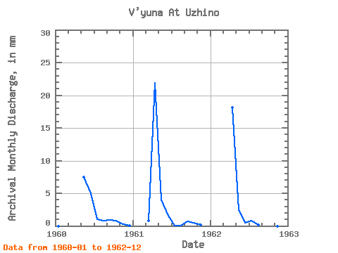
| Year | Jan | Feb | Mar | Apr | May | Jun | Jul | Aug | Sep | Oct | Nov | Dec | Annual | 1960 | 0.00 | 0.00 | 0.00 | 7.77 | 4.97 | 1.10 | 0.82 | 0.89 | 0.85 | 0.26 | 0.06 | 1961 | 0.00 | 0.00 | 0.83 | 21.89 | 4.16 | 1.61 | 0.01 | 0.08 | 0.72 | 0.51 | 0.13 | 0.00 | 30.23 | 1962 | 0.00 | 0.00 | 0.00 | 18.13 | 2.50 | 0.51 | 0.83 | 0.11 | 0.04 | 0.06 | 0.00 | 0.00 | 22.39 |
|---|
 Return to R-Arctic Net Home Page