|
|
|||||||||||||||||
| Point ID: 8460 | Downloads | Plots | Site Data | Code: 10227 |
|
|
|||||||||||||||||
| Download | |
|---|---|
| Site Descriptor Information | Site Time Series Data |
| Link to all available data | |
|
|
| View: | Statistics | Time Series |
| Units: | m3/s |
| Statistic | Jan | Feb | Mar | Apr | May | Jun | Jul | Aug | Sep | Oct | Nov | Dec | Annual |
|---|---|---|---|---|---|---|---|---|---|---|---|---|---|
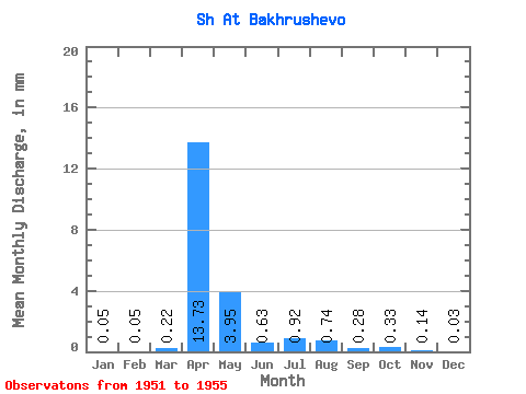
| Mean | 0.05 | 0.05 | 0.22 | 13.73 | 3.95 | 0.63 | 0.92 | 0.74 | 0.28 | 0.32 | 0.14 | 0.03 | 12.14 |
| Standard Deviation | 0.06 | 0.06 | 0.32 | 7.26 | 2.45 | 0.77 | 1.57 | 1.22 | 0.21 | 0.27 | 0.05 | 0.05 | 2.73 |
| Min | 0.00 | 0.00 | 0.00 | 4.87 | 1.48 | 0.15 | 0.11 | 0.12 | 0.13 | 0.13 | 0.09 | 0.00 | 10.21 |
| Max | 0.12 | 0.11 | 0.76 | 23.75 | 7.69 | 2.00 | 3.72 | 2.92 | 0.65 | 0.72 | 0.18 | 0.09 | 14.07 |
| Coefficient of Variation | 1.17 | 1.17 | 1.45 | 0.53 | 0.62 | 1.23 | 1.71 | 1.63 | 0.74 | 0.82 | 0.33 | 1.61 | 0.23 |
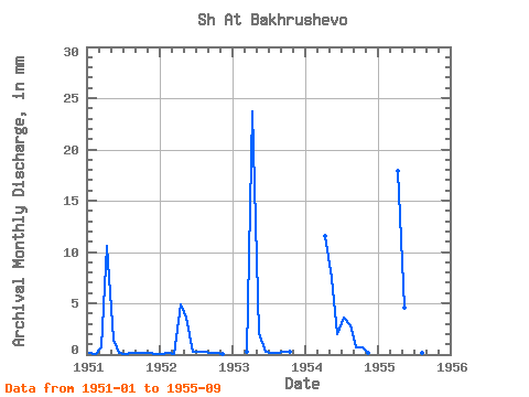
| Year | Jan | Feb | Mar | Apr | May | Jun | Jul | Aug | Sep | Oct | Nov | Dec | Annual | 1951 | 0.12 | 0.09 | 0.76 | 10.63 | 1.48 | 0.15 | 0.11 | 0.12 | 0.13 | 0.13 | 0.15 | 0.09 | 14.07 | 1952 | 0.09 | 0.11 | 0.06 | 4.87 | 3.72 | 0.31 | 0.30 | 0.27 | 0.18 | 0.20 | 0.09 | 0.00 | 10.21 | 1953 | 0.00 | 0.00 | 0.30 | 23.75 | 2.15 | 0.32 | 0.19 | 0.20 | 0.22 | 0.24 | 1954 | 0.00 | 11.53 | 7.69 | 2.00 | 3.72 | 2.92 | 0.65 | 0.72 | 0.18 | 0.00 | 1955 | 0.00 | 0.00 | 0.00 | 17.87 | 4.73 | 0.37 | 0.26 | 0.21 | 0.23 |
|---|
 Return to R-Arctic Net Home Page