|
|
|||||||||||||||||
| Point ID: 8436 | Downloads | Plots | Site Data | Code: 10124 |
|
|
|||||||||||||||||
| Download | |
|---|---|
| Site Descriptor Information | Site Time Series Data |
| Link to all available data | |
|
|
| View: | Statistics | Time Series |
| Units: | m3/s |
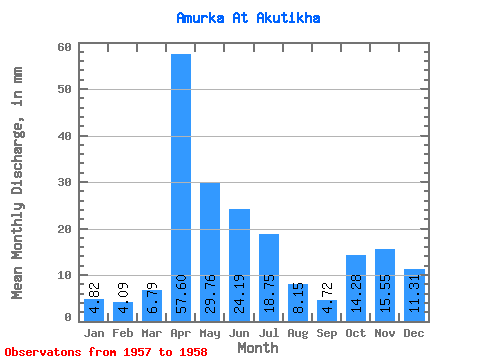
| Statistic | Jan | Feb | Mar | Apr | May | Jun | Jul | Aug | Sep | Oct | Nov | Dec | Annual |
|---|---|---|---|---|---|---|---|---|---|---|---|---|---|
| Mean | 4.85 | 4.09 | 6.78 | 57.60 | 29.76 | 24.19 | 18.75 | 8.15 | 4.72 | 14.30 | 15.57 | 11.32 | 200.22 |
| Standard Deviation | 4.08 | 2.65 | 2.19 | 35.03 | 15.99 | 20.36 | 21.46 | 6.99 | 2.28 | 10.12 | 8.17 | 7.60 | 132.57 |
| Min | 1.96 | 2.22 | 5.24 | 32.83 | 18.45 | 9.79 | 3.57 | 3.21 | 3.11 | 7.14 | 9.79 | 5.95 | 106.49 |
| Max | 7.74 | 5.96 | 8.33 | 82.37 | 41.06 | 38.59 | 33.92 | 13.09 | 6.34 | 21.46 | 21.35 | 16.70 | 293.96 |
| Coefficient of Variation | 0.84 | 0.65 | 0.32 | 0.61 | 0.54 | 0.84 | 1.15 | 0.86 | 0.48 | 0.71 | 0.53 | 0.67 | 0.66 |
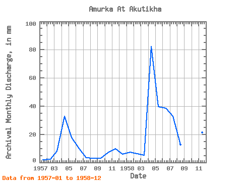
| Year | Jan | Feb | Mar | Apr | May | Jun | Jul | Aug | Sep | Oct | Nov | Dec | Annual | 1957 | 1.96 | 2.22 | 8.33 | 32.83 | 18.45 | 9.79 | 3.57 | 3.21 | 3.11 | 7.14 | 9.79 | 5.95 | 106.49 | 1958 | 7.74 | 5.96 | 5.24 | 82.37 | 41.06 | 38.59 | 33.92 | 13.09 | 6.34 | 21.46 | 21.35 | 16.70 | 293.96 |
|---|
 Return to R-Arctic Net Home Page