|
|
|||||||||||||||||
| Point ID: 8404 | Downloads | Plots | Site Data | Code: 9540 |
|
|
|||||||||||||||||
| Download | |
|---|---|
| Site Descriptor Information | Site Time Series Data |
| Link to all available data | |
|
|
| View: | Statistics | Time Series |
| Units: | m3/s |
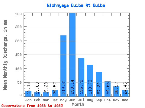
| Statistic | Jan | Feb | Mar | Apr | May | Jun | Jul | Aug | Sep | Oct | Nov | Dec | Annual |
|---|---|---|---|---|---|---|---|---|---|---|---|---|---|
| Mean | 19.19 | 16.04 | 15.28 | 24.57 | 219.29 | 299.13 | 136.70 | 113.72 | 87.21 | 54.66 | 36.37 | 24.44 | 1025.63 |
| Standard Deviation | 4.28 | 4.37 | 4.70 | 12.04 | 72.37 | 158.36 | 61.72 | 39.26 | 25.74 | 17.91 | 12.73 | 7.76 | 185.93 |
| Min | 12.42 | 8.59 | 7.63 | 10.86 | 89.47 | 108.75 | 56.40 | 45.03 | 49.96 | 0.00 | 19.55 | 14.51 | 691.29 |
| Max | 29.77 | 25.76 | 28.28 | 51.55 | 368.04 | 722.57 | 308.19 | 195.99 | 146.25 | 89.62 | 78.05 | 52.21 | 1305.30 |
| Coefficient of Variation | 0.22 | 0.27 | 0.31 | 0.49 | 0.33 | 0.53 | 0.45 | 0.34 | 0.29 | 0.33 | 0.35 | 0.32 | 0.18 |
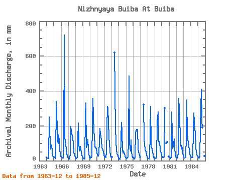
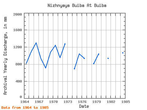
| Year | Jan | Feb | Mar | Apr | May | Jun | Jul | Aug | Sep | Oct | Nov | Dec | Annual | 1963 | 19.60 | 1964 | 18.10 | 14.04 | 12.12 | 13.18 | 258.82 | 165.08 | 68.67 | 86.47 | 89.49 | 50.57 | 26.64 | 24.54 | 823.82 | 1965 | 21.24 | 19.77 | 12.57 | 16.51 | 350.08 | 189.69 | 113.25 | 103.53 | 146.25 | 71.36 | 30.12 | 25.58 | 1094.61 | 1966 | 24.09 | 19.08 | 17.65 | 16.94 | 89.47 | 722.57 | 135.69 | 119.54 | 66.75 | 42.19 | 27.51 | 18.10 | 1305.30 | 1967 | 15.71 | 13.36 | 10.47 | 47.50 | 201.97 | 170.87 | 145.42 | 141.68 | 90.36 | 53.71 | 34.03 | 23.34 | 943.86 | 1968 | 15.71 | 11.45 | 13.02 | 22.73 | 222.92 | 108.75 | 56.40 | 71.21 | 80.37 | 53.11 | 30.99 | 26.33 | 709.22 | 1969 | 17.65 | 13.49 | 12.12 | 10.86 | 267.80 | 330.15 | 78.69 | 97.69 | 122.07 | 65.98 | 44.89 | 16.46 | 1076.39 | 1970 | 17.65 | 19.08 | 20.20 | 22.01 | 210.95 | 356.22 | 163.07 | 152.60 | 79.21 | 74.95 | 78.05 | 52.21 | 1243.15 | 1971 | 29.77 | 24.40 | 28.28 | 40.40 | 190.00 | 150.60 | 147.22 | 116.69 | 72.98 | 63.73 | 53.72 | 35.31 | 948.71 | 1972 | 23.19 | 25.76 | 20.35 | 48.37 | 194.49 | 309.88 | 308.19 | 141.68 | 98.32 | 55.80 | 29.68 | 22.74 | 1273.86 | 1973 | 23.04 | 619.76 | 194.49 | 110.41 | 65.31 | 39.80 | 29.25 | 16.16 | 1974 | 13.61 | 8.59 | 7.63 | 23.02 | 227.41 | 160.73 | 63.13 | 45.03 | 57.05 | 40.39 | 27.51 | 20.05 | 691.29 | 1975 | 14.36 | 13.09 | 14.96 | 20.27 | 112.51 | 485.10 | 102.03 | 56.55 | 118.88 | 53.26 | 30.55 | 20.65 | 1046.12 | 1976 | 18.85 | 12.68 | 9.87 | 19.69 | 167.56 | 179.56 | 179.53 | 185.51 | 66.61 | 50.42 | 33.30 | 22.00 | 939.61 | 1977 | 322.91 | 121.48 | 101.14 | 61.83 | 50.72 | 32.15 | 22.59 | 1978 | 16.16 | 10.90 | 10.77 | 22.59 | 167.56 | 309.88 | 84.83 | 70.61 | 49.96 | 34.41 | 19.55 | 14.51 | 811.33 | 1979 | 12.42 | 13.77 | 14.81 | 16.07 | 227.41 | 280.92 | 127.32 | 98.59 | 110.92 | 62.98 | 45.47 | 29.17 | 1037.31 | 1980 | 23.34 | 18.81 | 19.60 | 21.29 | 312.68 | 105.92 | 108.60 | 0.00 | 25.43 | 1981 | 20.95 | 17.72 | 14.06 | 19.11 | 290.24 | 149.15 | 72.86 | 98.89 | 125.69 | 69.42 | 39.53 | 23.64 | 936.96 | 1982 | 18.85 | 16.90 | 16.91 | 51.55 | 368.04 | 238.93 | 139.88 | 99.34 | 67.48 | 89.62 | 50.11 | 26.63 | 1177.93 | 1983 | 17.95 | 15.54 | 15.86 | 18.97 | 148.86 | 347.53 | 152.60 | 130.61 | 77.91 | 71.06 | 38.95 | 30.37 | 1064.34 | 1984 | 24.09 | 18.13 | 18.10 | 19.41 | 179.53 | 273.68 | 179.53 | 172.05 | 66.32 | 57.61 | 33.75 | 26.78 | 1064.37 | 1985 | 16.16 | 14.18 | 16.31 | 20.85 | 197.48 | 409.80 | 236.38 | 195.99 | 96.30 | 51.33 | 27.96 | 19.90 | 1298.72 |
|---|
 Return to R-Arctic Net Home Page