|
|
|||||||||||||||||
| Point ID: 8386 | Downloads | Plots | Site Data | Code: 9474 |
|
|
|||||||||||||||||
| Download | |
|---|---|
| Site Descriptor Information | Site Time Series Data |
| Link to all available data | |
|
|
| View: | Statistics | Time Series |
| Units: | m3/s |
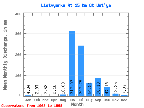
| Statistic | Jan | Feb | Mar | Apr | May | Jun | Jul | Aug | Sep | Oct | Nov | Dec | Annual |
|---|---|---|---|---|---|---|---|---|---|---|---|---|---|
| Mean | 4.82 | 3.01 | 2.53 | 2.17 | 10.01 | 312.09 | 242.70 | 64.49 | 90.15 | 47.13 | 13.36 | 7.07 | 798.27 |
| Standard Deviation | 2.84 | 2.06 | 1.68 | 1.58 | 16.10 | 99.32 | 121.33 | 45.15 | 37.26 | 31.16 | 4.62 | 3.44 | 138.35 |
| Min | 0.00 | 0.00 | 0.00 | 0.00 | 0.00 | 223.58 | 82.81 | 29.06 | 33.75 | 23.25 | 6.09 | 0.78 | 613.17 |
| Max | 7.26 | 4.85 | 4.46 | 3.94 | 42.62 | 445.75 | 452.79 | 147.70 | 131.24 | 108.96 | 19.69 | 11.14 | 997.83 |
| Coefficient of Variation | 0.59 | 0.68 | 0.67 | 0.73 | 1.61 | 0.32 | 0.50 | 0.70 | 0.41 | 0.66 | 0.35 | 0.49 | 0.17 |
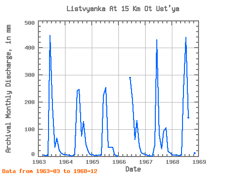
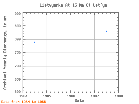
| Year | Jan | Feb | Mar | Apr | May | Jun | Jul | Aug | Sep | Oct | Nov | Dec | Annual | 1963 | 4.46 | 3.19 | 2.95 | 445.75 | 192.25 | 34.38 | 66.56 | 23.25 | 12.19 | 7.26 | 1964 | 6.29 | 4.85 | 2.13 | 1.64 | 5.81 | 241.39 | 253.76 | 77.48 | 128.90 | 44.55 | 16.41 | 7.26 | 789.43 | 1965 | 5.81 | 3.31 | 3.29 | 3.94 | 4.84 | 223.58 | 261.50 | 33.90 | 33.75 | 34.38 | 6.09 | 0.78 | 613.17 | 1966 | 0.00 | 0.00 | 0.00 | 0.00 | 0.00 | 288.73 | 213.08 | 64.41 | 131.24 | 40.19 | 14.06 | 8.72 | 760.94 | 1967 | 7.26 | 2.03 | 1.36 | 0.84 | 42.62 | 428.41 | 82.81 | 29.06 | 92.81 | 108.96 | 19.69 | 11.14 | 830.00 | 1968 | 4.75 | 4.85 | 3.92 | 3.42 | 3.83 | 244.67 | 452.79 | 147.70 | 87.65 | 31.48 | 11.72 | 7.26 | 997.83 |
|---|
 Return to R-Arctic Net Home Page