|
|
|||||||||||||||||
| Point ID: 8385 | Downloads | Plots | Site Data | Code: 9473 |
|
|
|||||||||||||||||
| Download | |
|---|---|
| Site Descriptor Information | Site Time Series Data |
| Link to all available data | |
|
|
| View: | Statistics | Time Series |
| Units: | m3/s |
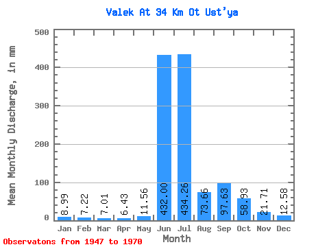
| Statistic | Jan | Feb | Mar | Apr | May | Jun | Jul | Aug | Sep | Oct | Nov | Dec | Annual |
|---|---|---|---|---|---|---|---|---|---|---|---|---|---|
| Mean | 8.98 | 7.29 | 7.01 | 6.43 | 11.56 | 432.00 | 434.19 | 73.64 | 97.63 | 58.93 | 21.71 | 12.59 | 1236.17 |
| Standard Deviation | 5.80 | 4.48 | 5.48 | 4.41 | 4.02 | 174.32 | 296.94 | 55.06 | 26.11 | 34.91 | 8.05 | 5.59 | 279.98 |
| Min | 4.33 | 4.67 | 3.45 | 3.05 | 7.19 | 185.82 | 170.33 | 27.96 | 69.28 | 33.28 | 11.15 | 4.23 | 966.04 |
| Max | 17.33 | 13.99 | 15.06 | 12.58 | 16.54 | 704.22 | 1053.48 | 191.99 | 145.80 | 117.16 | 34.02 | 21.66 | 1626.54 |
| Coefficient of Variation | 0.65 | 0.61 | 0.78 | 0.69 | 0.35 | 0.40 | 0.68 | 0.75 | 0.27 | 0.59 | 0.37 | 0.44 | 0.23 |
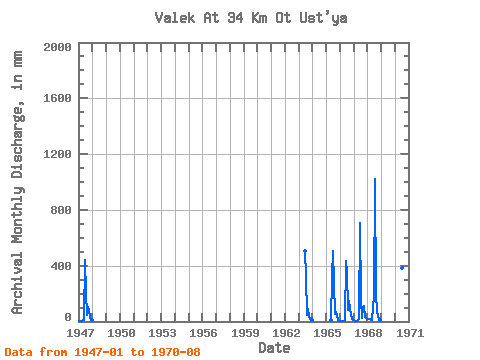
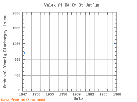
| Year | Jan | Feb | Mar | Apr | May | Jun | Jul | Aug | Sep | Oct | Nov | Dec | Annual | 1947 | 5.91 | 5.38 | 5.91 | 6.67 | 14.38 | 440.26 | 207.74 | 49.23 | 102.92 | 86.64 | 27.35 | 11.62 | 966.04 | 1963 | 503.15 | 326.87 | 46.57 | 89.58 | 33.38 | 20.49 | 11.42 | 1965 | 11.72 | 322.09 | 518.86 | 53.56 | 69.28 | 38.59 | 11.15 | 4.23 | 1966 | 4.33 | 4.67 | 3.64 | 3.43 | 7.19 | 436.45 | 369.21 | 86.54 | 145.80 | 44.50 | 20.68 | 13.98 | 1140.18 | 1967 | 8.37 | 5.11 | 3.45 | 3.05 | 16.54 | 704.22 | 170.33 | 27.96 | 93.96 | 117.16 | 34.02 | 21.66 | 1211.93 | 1968 | 17.33 | 13.99 | 15.06 | 12.58 | 7.97 | 185.82 | 1053.48 | 191.99 | 84.24 | 33.28 | 16.58 | 12.60 | 1626.54 | 1970 | 392.84 | 59.66 |
|---|
 Return to R-Arctic Net Home Page