|
|
|||||||||||||||||
| Point ID: 8353 | Downloads | Plots | Site Data | Code: 9328 |
|
|
|||||||||||||||||
| Download | |
|---|---|
| Site Descriptor Information | Site Time Series Data |
| Link to all available data | |
|
|
| View: | Statistics | Time Series |
| Units: | m3/s |
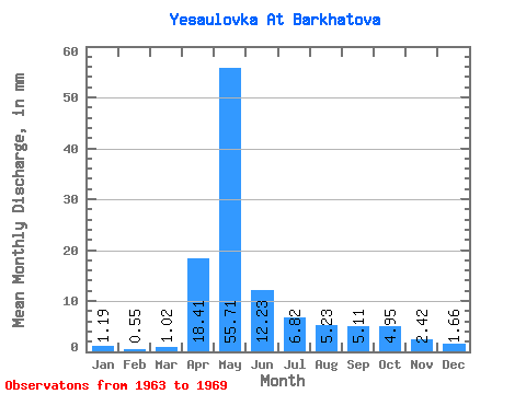
| Statistic | Jan | Feb | Mar | Apr | May | Jun | Jul | Aug | Sep | Oct | Nov | Dec | Annual |
|---|---|---|---|---|---|---|---|---|---|---|---|---|---|
| Mean | 1.19 | 0.55 | 1.02 | 18.41 | 55.70 | 12.23 | 6.82 | 5.23 | 5.11 | 4.94 | 2.42 | 1.66 | 114.79 |
| Standard Deviation | 0.66 | 0.44 | 0.59 | 17.40 | 45.42 | 7.70 | 1.29 | 0.92 | 1.45 | 1.29 | 0.95 | 0.86 | 47.07 |
| Min | 0.05 | 0.00 | 0.14 | 2.27 | 19.06 | 7.23 | 4.94 | 3.90 | 4.16 | 3.84 | 1.02 | 0.17 | 73.95 |
| Max | 1.91 | 1.25 | 1.77 | 48.02 | 140.54 | 27.73 | 8.68 | 6.25 | 7.94 | 7.37 | 3.44 | 2.64 | 199.13 |
| Coefficient of Variation | 0.56 | 0.81 | 0.58 | 0.94 | 0.81 | 0.63 | 0.19 | 0.17 | 0.28 | 0.26 | 0.39 | 0.52 | 0.41 |
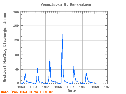
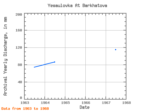
| Year | Jan | Feb | Mar | Apr | May | Jun | Jul | Aug | Sep | Oct | Nov | Dec | Annual | 1963 | 1.18 | 0.60 | 0.98 | 8.92 | 30.93 | 7.23 | 6.27 | 4.46 | 4.16 | 4.13 | 3.31 | 2.26 | 73.95 | 1964 | 1.74 | 0.66 | 0.66 | 7.03 | 45.67 | 9.12 | 4.94 | 5.46 | 4.32 | 4.26 | 1.59 | 1.93 | 86.61 | 1965 | 1.91 | 1.25 | 1.58 | 14.06 | 71.00 | 10.73 | 7.04 | 5.19 | 7.94 | 7.37 | 3.44 | 2.64 | 133.03 | 1966 | 1.70 | 0.87 | 1.00 | 2.27 | 140.54 | 27.73 | 8.68 | 6.10 | 4.66 | 3.84 | 2.45 | 1.60 | 199.13 | 1967 | 0.93 | 0.42 | 0.14 | 48.02 | 26.99 | 10.27 | 7.66 | 6.25 | 5.37 | 5.21 | 2.69 | 1.35 | 115.44 | 1968 | 0.77 | 0.05 | 1.77 | 30.14 | 19.06 | 8.32 | 6.33 | 3.90 | 4.22 | 4.86 | 1.02 | 0.17 | 80.59 | 1969 | 0.05 | 0.00 |
|---|
 Return to R-Arctic Net Home Page