|
|
|||||||||||||||||
| Point ID: 8316 | Downloads | Plots | Site Data | Code: 9215 |
|
|
|||||||||||||||||
| Download | |
|---|---|
| Site Descriptor Information | Site Time Series Data |
| Link to all available data | |
|
|
| View: | Statistics | Time Series |
| Units: | m3/s |
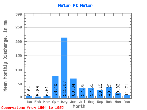
| Statistic | Jan | Feb | Mar | Apr | May | Jun | Jul | Aug | Sep | Oct | Nov | Dec | Annual |
|---|---|---|---|---|---|---|---|---|---|---|---|---|---|
| Mean | 8.63 | 5.94 | 6.61 | 78.39 | 213.04 | 68.84 | 37.04 | 37.52 | 28.15 | 40.28 | 19.33 | 11.71 | 552.45 |
| Standard Deviation | 3.31 | 2.59 | 3.07 | 40.75 | 69.48 | 37.06 | 26.77 | 28.61 | 11.54 | 23.95 | 8.21 | 3.76 | 107.62 |
| Min | 2.80 | 1.66 | 1.26 | 12.52 | 114.67 | 25.31 | 11.68 | 8.67 | 13.81 | 9.65 | 8.26 | 6.71 | 369.09 |
| Max | 15.94 | 12.42 | 13.84 | 175.28 | 363.59 | 146.18 | 116.07 | 135.65 | 53.67 | 88.80 | 35.46 | 18.81 | 765.45 |
| Coefficient of Variation | 0.38 | 0.44 | 0.46 | 0.52 | 0.33 | 0.54 | 0.72 | 0.76 | 0.41 | 0.59 | 0.42 | 0.32 | 0.20 |
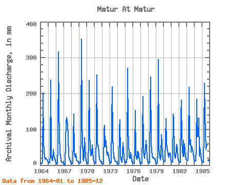
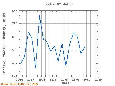
| Year | Jan | Feb | Mar | Apr | May | Jun | Jul | Aug | Sep | Oct | Nov | Dec | Annual | 1964 | 6.92 | 3.76 | 4.62 | 12.52 | 208.37 | 61.04 | 21.54 | 19.02 | 20.30 | 16.36 | 14.41 | 11.89 | 397.45 | 1965 | 8.25 | 6.24 | 7.13 | 30.79 | 245.43 | 25.31 | 13.63 | 13.78 | 43.38 | 27.34 | 17.73 | 12.45 | 447.79 | 1966 | 8.81 | 4.27 | 3.99 | 51.16 | 327.23 | 146.18 | 34.05 | 28.88 | 13.87 | 9.65 | 8.26 | 6.71 | 639.10 | 1967 | 4.47 | 1.66 | 1.26 | 67.68 | 122.36 | 131.97 | 116.07 | 81.81 | 25.79 | 21.75 | 12.59 | 7.20 | 591.85 | 1968 | 5.94 | 3.19 | 5.87 | 71.06 | 146.84 | 32.96 | 23.56 | 33.70 | 15.84 | 12.59 | 11.44 | 8.18 | 369.09 | 1969 | 7.20 | 4.91 | 7.34 | 95.42 | 363.59 | 119.11 | 18.67 | 12.52 | 27.68 | 79.71 | 21.79 | 12.24 | 765.45 | 1970 | 7.69 | 5.73 | 4.20 | 66.39 | 243.33 | 81.89 | 27.90 | 29.30 | 33.63 | 58.10 | 17.46 | 10.98 | 583.13 | 1971 | 7.69 | 6.05 | 4.75 | 91.36 | 260.11 | 60.37 | 53.35 | 33.49 | 17.05 | 13.36 | 10.02 | 7.13 | 561.02 | 1972 | 4.75 | 3.19 | 3.85 | 97.45 | 114.67 | 50.62 | 70.62 | 41.53 | 28.22 | 38.18 | 25.99 | 13.49 | 490.64 | 1973 | 10.07 | 6.88 | 6.50 | 118.43 | 226.55 | 75.12 | 22.16 | 23.21 | 13.81 | 11.68 | 9.07 | 7.13 | 528.82 | 1974 | 4.75 | 2.55 | 3.64 | 98.81 | 131.45 | 26.73 | 11.68 | 8.67 | 34.65 | 65.10 | 20.71 | 9.58 | 416.95 | 1975 | 9.72 | 8.35 | 7.27 | 23.69 | 278.99 | 98.81 | 27.27 | 20.21 | 19.42 | 36.92 | 12.86 | 7.90 | 547.36 | 1976 | 6.92 | 5.03 | 4.54 | 46.09 | 157.32 | 30.66 | 17.06 | 39.37 | 20.57 | 37.55 | 12.99 | 7.76 | 383.03 | 1977 | 2.80 | 4.84 | 4.96 | 89.33 | 197.88 | 36.48 | 20.14 | 41.74 | 43.45 | 72.02 | 22.33 | 11.82 | 544.68 | 1978 | 9.65 | 6.24 | 6.22 | 175.28 | 254.51 | 59.76 | 26.43 | 21.12 | 21.66 | 19.44 | 17.60 | 12.73 | 628.87 | 1979 | 8.39 | 3.95 | 6.50 | 37.22 | 304.16 | 45.68 | 22.38 | 15.31 | 25.11 | 88.80 | 35.46 | 16.01 | 603.12 | 1980 | 12.38 | 8.41 | 10.98 | 72.41 | 133.55 | 59.55 | 41.39 | 31.32 | 21.52 | 32.86 | 34.31 | 17.83 | 474.91 | 1981 | 9.86 | 7.45 | 9.02 | 142.12 | 132.15 | 31.54 | 19.51 | 26.43 | 47.03 | 59.99 | 22.67 | 15.10 | 522.15 | 1982 | 11.19 | 8.66 | 8.11 | 138.74 | 188.09 | 63.68 | 25.38 | 71.32 | 24.43 | 61.46 | 23.01 | 17.55 | 639.10 | 1983 | 15.94 | 12.42 | 13.84 | 58.95 | 224.45 | 58.41 | 73.42 | 38.18 | 53.67 | 47.48 | 34.52 | 18.81 | 646.31 | 1984 | 15.38 | 9.81 | 13.14 | 49.06 | 190.19 | 79.18 | 83.91 | 135.65 | 24.57 | 52.93 | 26.19 | 13.91 | 688.26 | 1985 | 11.19 | 7.01 | 7.69 | 90.69 | 235.64 | 139.41 | 44.82 | 58.87 | 43.72 | 22.93 | 13.87 | 11.33 | 684.90 |
|---|
 Return to R-Arctic Net Home Page