|
|
|||||||||||||||||
| Point ID: 8301 | Downloads | Plots | Site Data | Code: 9176 |
|
|
|||||||||||||||||
| Download | |
|---|---|
| Site Descriptor Information | Site Time Series Data |
| Link to all available data | |
|
|
| View: | Statistics | Time Series |
| Units: | m3/s |
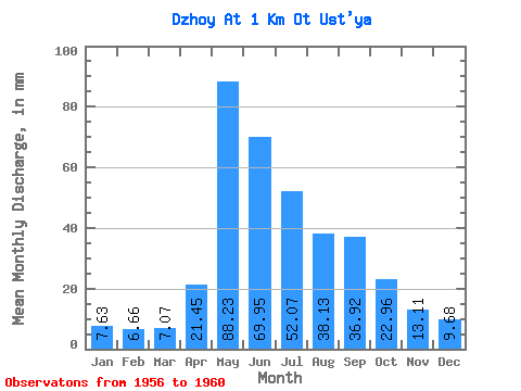
| Statistic | Jan | Feb | Mar | Apr | May | Jun | Jul | Aug | Sep | Oct | Nov | Dec | Annual |
|---|---|---|---|---|---|---|---|---|---|---|---|---|---|
| Mean | 7.62 | 6.72 | 7.07 | 21.45 | 88.22 | 69.95 | 52.06 | 38.13 | 36.92 | 22.95 | 13.11 | 9.68 | 403.35 |
| Standard Deviation | 1.00 | 1.22 | 1.39 | 5.41 | 31.86 | 20.65 | 24.21 | 13.13 | 12.73 | 5.73 | 4.25 | 2.17 | 35.19 |
| Min | 6.24 | 5.05 | 5.89 | 13.84 | 47.89 | 53.98 | 26.53 | 17.05 | 24.91 | 16.41 | 9.67 | 6.90 | 374.70 |
| Max | 8.47 | 7.92 | 8.98 | 25.65 | 129.49 | 102.16 | 87.27 | 51.35 | 54.58 | 30.53 | 20.19 | 12.85 | 447.81 |
| Coefficient of Variation | 0.13 | 0.18 | 0.20 | 0.25 | 0.36 | 0.29 | 0.47 | 0.34 | 0.34 | 0.25 | 0.32 | 0.22 | 0.09 |
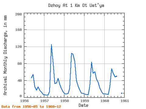
| Year | Jan | Feb | Mar | Apr | May | Jun | Jul | Aug | Sep | Oct | Nov | Dec | Annual | 1956 | 47.89 | 53.98 | 26.53 | 17.05 | 24.91 | 16.41 | 12.44 | 6.90 | 1957 | 6.24 | 5.05 | 5.89 | 13.84 | 129.49 | 79.28 | 33.71 | 35.29 | 44.83 | 30.53 | 20.19 | 12.85 | 415.35 | 1958 | 8.47 | 7.92 | 8.98 | 21.35 | 107.75 | 102.16 | 87.27 | 41.90 | 25.83 | 18.27 | 9.97 | 10.05 | 447.81 | 1959 | 7.56 | 6.69 | 6.21 | 25.65 | 86.33 | 57.02 | 62.70 | 45.05 | 34.46 | 23.66 | 13.29 | 8.79 | 375.53 | 1960 | 8.22 | 7.21 | 7.21 | 24.98 | 69.63 | 57.33 | 50.09 | 51.35 | 54.58 | 25.90 | 9.67 | 9.80 | 374.70 |
|---|
 Return to R-Arctic Net Home Page