|
|
|||||||||||||||||
| Point ID: 8300 | Downloads | Plots | Site Data | Code: 9174 |
|
|
|||||||||||||||||
| Download | |
|---|---|
| Site Descriptor Information | Site Time Series Data |
| Link to all available data | |
|
|
| View: | Statistics | Time Series |
| Units: | m3/s |
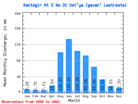
| Statistic | Jan | Feb | Mar | Apr | May | Jun | Jul | Aug | Sep | Oct | Nov | Dec | Annual |
|---|---|---|---|---|---|---|---|---|---|---|---|---|---|
| Mean | 9.27 | 6.80 | 7.01 | 18.54 | 100.67 | 134.00 | 104.06 | 93.07 | 65.06 | 33.00 | 16.81 | 12.30 | 625.79 |
| Standard Deviation | 1.68 | 0.67 | 1.23 | 15.33 | 24.34 | 39.86 | 38.51 | 24.54 | 15.71 | 5.61 | 4.88 | 2.96 | 107.59 |
| Min | 7.69 | 5.83 | 5.21 | 7.39 | 61.00 | 87.84 | 60.50 | 51.58 | 45.74 | 26.63 | 11.18 | 8.48 | 536.42 |
| Max | 11.75 | 7.64 | 8.58 | 45.50 | 126.96 | 187.20 | 145.80 | 123.49 | 85.44 | 42.85 | 23.33 | 16.41 | 800.25 |
| Coefficient of Variation | 0.18 | 0.10 | 0.17 | 0.83 | 0.24 | 0.30 | 0.37 | 0.26 | 0.24 | 0.17 | 0.29 | 0.24 | 0.17 |
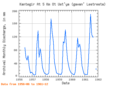
| Year | Jan | Feb | Mar | Apr | May | Jun | Jul | Aug | Sep | Oct | Nov | Dec | Annual | 1956 | 87.84 | 60.50 | 51.58 | 63.36 | 30.10 | 11.18 | 14.68 | 1957 | 11.75 | 5.83 | 5.21 | 7.39 | 99.68 | 137.76 | 60.50 | 86.79 | 65.28 | 30.30 | 16.61 | 11.01 | 536.42 | 1958 | 9.42 | 6.69 | 8.58 | 11.52 | 107.12 | 173.76 | 136.38 | 108.11 | 45.74 | 26.63 | 11.18 | 10.22 | 652.14 | 1959 | 7.74 | 7.64 | 7.24 | 13.92 | 108.61 | 101.28 | 145.80 | 87.28 | 50.40 | 33.13 | 20.06 | 12.99 | 592.19 | 1960 | 9.77 | 7.18 | 6.64 | 14.35 | 61.00 | 116.16 | 91.25 | 101.17 | 80.16 | 35.01 | 18.48 | 8.48 | 547.97 | 1961 | 7.69 | 6.69 | 7.39 | 45.50 | 126.96 | 187.20 | 129.93 | 123.49 | 85.44 | 42.85 | 23.33 | 16.41 | 800.25 |
|---|
 Return to R-Arctic Net Home Page