|
|
|||||||||||||||||
| Point ID: 8287 | Downloads | Plots | Site Data | Code: 9120 |
|
|
|||||||||||||||||
| Download | |
|---|---|
| Site Descriptor Information | Site Time Series Data |
| Link to all available data | |
|
|
| View: | Statistics | Time Series |
| Units: | m3/s |
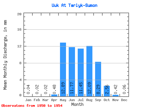
| Statistic | Jan | Feb | Mar | Apr | May | Jun | Jul | Aug | Sep | Oct | Nov | Dec | Annual |
|---|---|---|---|---|---|---|---|---|---|---|---|---|---|
| Mean | 0.04 | 0.02 | 0.02 | 0.48 | 12.88 | 11.77 | 11.45 | 12.09 | 8.29 | 2.56 | 0.42 | 0.06 | 95.54 |
| Standard Deviation | 6.62 | 7.58 | 7.71 | 5.86 | 6.40 | 1.66 | 0.27 | 0.04 | |||||
| Min | 0.04 | 0.02 | 0.02 | 0.48 | 5.43 | 4.52 | 2.65 | 2.65 | 0.92 | 0.95 | 0.11 | 0.03 | 95.54 |
| Max | 0.04 | 0.02 | 0.02 | 0.48 | 18.06 | 21.46 | 20.02 | 18.70 | 15.40 | 4.99 | 0.80 | 0.11 | 95.54 |
| Coefficient of Variation | 0.51 | 0.64 | 0.67 | 0.48 | 0.77 | 0.65 | 0.64 | 0.57 |
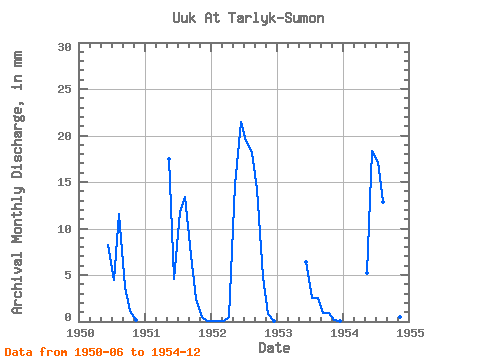
| Year | Jan | Feb | Mar | Apr | May | Jun | Jul | Aug | Sep | Oct | Nov | Dec | Annual | 1950 | 8.19 | 4.61 | 11.94 | 3.67 | 1.14 | 0.21 | 1951 | 18.06 | 4.52 | 12.19 | 13.83 | 7.15 | 2.46 | 0.49 | 0.11 | 1952 | 0.04 | 0.02 | 0.02 | 0.48 | 15.16 | 21.46 | 20.02 | 18.70 | 14.30 | 4.99 | 0.80 | 0.08 | 95.54 | 1953 | 6.42 | 2.65 | 2.65 | 0.92 | 0.95 | 0.11 | 0.04 | 1954 | 5.43 | 18.28 | 17.75 | 13.33 | 15.40 | 3.28 | 0.50 | 0.03 |
|---|
 Return to R-Arctic Net Home Page