|
|
|||||||||||||||||
| Point ID: 8276 | Downloads | Plots | Site Data | Code: 8401 |
|
|
|||||||||||||||||
| Download | |
|---|---|
| Site Descriptor Information | Site Time Series Data |
| Link to all available data | |
|
|
| View: | Statistics | Time Series |
| Units: | m3/s |
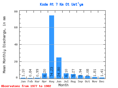
| Statistic | Jan | Feb | Mar | Apr | May | Jun | Jul | Aug | Sep | Oct | Nov | Dec | Annual |
|---|---|---|---|---|---|---|---|---|---|---|---|---|---|
| Mean | 1.10 | 0.85 | 0.99 | 6.20 | 74.22 | 24.80 | 6.10 | 5.27 | 3.94 | 3.08 | 1.81 | 1.41 | 125.95 |
| Standard Deviation | 0.13 | 0.10 | 0.17 | 7.39 | 20.81 | 10.46 | 3.73 | 4.29 | 1.09 | 0.52 | 0.37 | 0.22 | 28.54 |
| Min | 0.95 | 0.70 | 0.77 | 1.01 | 47.58 | 6.58 | 3.96 | 2.89 | 2.58 | 2.51 | 1.51 | 1.20 | 91.87 |
| Max | 1.28 | 0.95 | 1.26 | 19.12 | 106.42 | 37.77 | 13.56 | 13.98 | 5.40 | 3.79 | 2.44 | 1.77 | 169.07 |
| Coefficient of Variation | 0.11 | 0.12 | 0.17 | 1.19 | 0.28 | 0.42 | 0.61 | 0.81 | 0.28 | 0.17 | 0.20 | 0.16 | 0.23 |
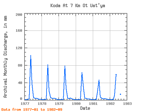
| Year | Jan | Feb | Mar | Apr | May | Jun | Jul | Aug | Sep | Oct | Nov | Dec | Annual | 1977 | 1.28 | 0.93 | 1.26 | 2.99 | 106.42 | 37.77 | 5.36 | 3.80 | 4.02 | 3.42 | 1.51 | 1.77 | 169.07 | 1978 | 1.22 | 0.87 | 0.97 | 1.61 | 84.17 | 21.00 | 5.54 | 3.80 | 3.88 | 3.79 | 2.44 | 1.38 | 129.35 | 1979 | 0.95 | 0.70 | 0.96 | 1.35 | 81.38 | 26.66 | 3.96 | 3.09 | 4.85 | 2.75 | 1.63 | 1.20 | 128.36 | 1980 | 1.00 | 0.73 | 0.77 | 1.01 | 65.31 | 27.07 | 4.00 | 4.06 | 2.58 | 2.51 | 1.68 | 1.29 | 111.12 | 1981 | 1.08 | 0.95 | 1.07 | 19.12 | 47.58 | 6.58 | 4.15 | 2.89 | 2.90 | 2.95 | 1.79 | 1.38 | 91.87 | 1982 | 1.11 | 0.89 | 0.91 | 11.11 | 60.45 | 29.69 | 13.56 | 13.98 | 5.40 |
|---|
 Return to R-Arctic Net Home Page