|
|
|||||||||||||||||
| Point ID: 8267 | Downloads | Plots | Site Data | Code: 8383 |
|
|
|||||||||||||||||
| Download | |
|---|---|
| Site Descriptor Information | Site Time Series Data |
| Link to all available data | |
|
|
| View: | Statistics | Time Series |
| Units: | m3/s |
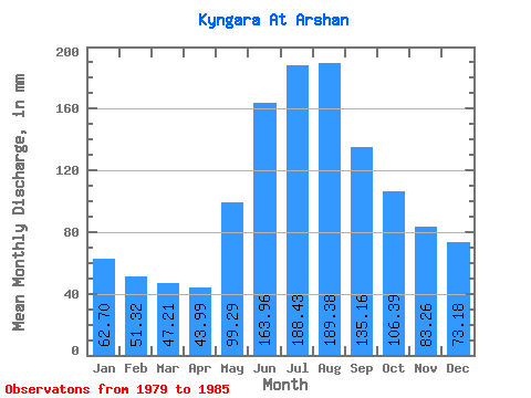
| Statistic | Jan | Feb | Mar | Apr | May | Jun | Jul | Aug | Sep | Oct | Nov | Dec | Annual |
|---|---|---|---|---|---|---|---|---|---|---|---|---|---|
| Mean | 62.67 | 51.76 | 47.23 | 43.96 | 99.30 | 163.96 | 188.41 | 189.35 | 135.16 | 106.40 | 83.24 | 73.15 | 1224.81 |
| Standard Deviation | 10.41 | 11.04 | 11.86 | 10.74 | 15.51 | 64.23 | 69.62 | 49.58 | 25.17 | 18.68 | 13.13 | 13.05 | 245.76 |
| Min | 45.99 | 35.12 | 32.46 | 30.11 | 75.74 | 97.53 | 128.49 | 127.14 | 106.69 | 81.15 | 62.18 | 53.42 | 961.68 |
| Max | 75.06 | 64.70 | 61.54 | 53.67 | 116.32 | 276.87 | 292.82 | 253.60 | 170.18 | 131.19 | 97.53 | 92.65 | 1536.82 |
| Coefficient of Variation | 0.17 | 0.21 | 0.25 | 0.24 | 0.16 | 0.39 | 0.37 | 0.26 | 0.19 | 0.18 | 0.16 | 0.18 | 0.20 |
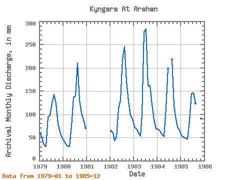
| Year | Jan | Feb | Mar | Apr | May | Jun | Jul | Aug | Sep | Oct | Nov | Dec | Annual | 1979 | 62.89 | 44.98 | 35.17 | 30.76 | 97.38 | 97.53 | 128.49 | 147.43 | 123.06 | 81.15 | 62.18 | 53.42 | 961.68 | 1980 | 45.99 | 35.12 | 32.46 | 30.11 | 75.74 | 136.15 | 143.37 | 217.08 | 130.25 | 104.82 | 88.36 | 73.04 | 1108.45 | 1982 | 65.60 | 57.30 | 45.31 | 51.05 | 114.97 | 130.25 | 226.55 | 253.60 | 170.18 | 131.19 | 97.53 | 92.65 | 1430.56 | 1983 | 75.06 | 64.70 | 61.54 | 53.67 | 102.12 | 276.87 | 292.82 | 166.36 | 161.67 | 125.11 | 88.36 | 71.01 | 1536.82 | 1984 | 70.33 | 60.38 | 58.16 | 51.71 | 116.32 | 198.33 | 224.52 | 119.13 | 98.06 | 72.66 | 68.30 | 1985 | 56.13 | 48.06 | 50.72 | 46.47 | 89.27 | 144.66 | 150.81 | 127.14 | 106.69 | 98.06 | 90.33 | 80.47 | 1086.54 |
|---|
 Return to R-Arctic Net Home Page