|
|
|||||||||||||||||
| Point ID: 8220 | Downloads | Plots | Site Data | Code: 8250 |
|
|
|||||||||||||||||
| Download | |
|---|---|
| Site Descriptor Information | Site Time Series Data |
| Link to all available data | |
|
|
| View: | Statistics | Time Series |
| Units: | m3/s |
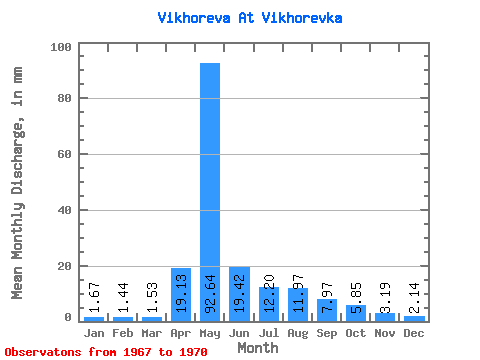
| Statistic | Jan | Feb | Mar | Apr | May | Jun | Jul | Aug | Sep | Oct | Nov | Dec | Annual |
|---|---|---|---|---|---|---|---|---|---|---|---|---|---|
| Mean | 1.66 | 1.45 | 1.53 | 19.13 | 92.62 | 19.42 | 12.20 | 11.96 | 7.97 | 5.85 | 3.19 | 2.14 | 164.43 |
| Standard Deviation | 1.01 | 0.70 | 0.54 | 27.44 | 6.20 | 7.92 | 7.17 | 11.29 | 5.81 | 2.93 | 1.54 | 1.45 | 27.79 |
| Min | 0.91 | 0.93 | 1.19 | 2.39 | 85.67 | 10.08 | 4.37 | 3.80 | 3.68 | 3.29 | 1.90 | 1.08 | 140.50 |
| Max | 2.81 | 2.25 | 2.16 | 50.80 | 100.71 | 27.46 | 20.54 | 28.65 | 16.39 | 8.94 | 5.38 | 4.28 | 194.91 |
| Coefficient of Variation | 0.61 | 0.49 | 0.35 | 1.43 | 0.07 | 0.41 | 0.59 | 0.94 | 0.73 | 0.50 | 0.48 | 0.68 | 0.17 |
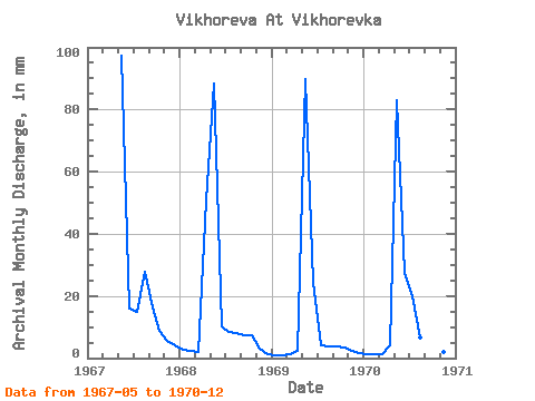
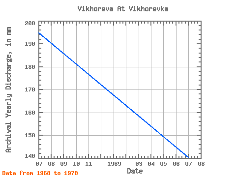
| Year | Jan | Feb | Mar | Apr | May | Jun | Jul | Aug | Sep | Oct | Nov | Dec | Annual | 1967 | 100.71 | 15.87 | 15.35 | 28.65 | 16.39 | 8.94 | 5.38 | 4.28 | 1968 | 2.81 | 2.25 | 2.16 | 50.80 | 91.35 | 10.08 | 8.54 | 8.43 | 7.22 | 7.77 | 3.02 | 1.48 | 194.91 | 1969 | 0.91 | 0.93 | 1.19 | 2.39 | 92.77 | 24.27 | 4.37 | 3.80 | 3.68 | 3.40 | 2.44 | 1.73 | 140.50 | 1970 | 1.28 | 1.16 | 1.25 | 4.20 | 85.67 | 27.46 | 20.54 | 6.98 | 4.58 | 3.29 | 1.90 | 1.08 | 157.88 |
|---|
 Return to R-Arctic Net Home Page