|
|
|||||||||||||||||
| Point ID: 8133 | Downloads | Plots | Site Data | Code: 1624 |
|
|
|||||||||||||||||
| Download | |
|---|---|
| Site Descriptor Information | Site Time Series Data |
| Link to all available data | |
|
|
| View: | Statistics | Time Series |
| Units: | m3/s |
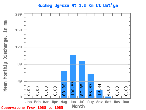
| Statistic | Jan | Feb | Mar | Apr | May | Jun | Jul | Aug | Sep | Oct | Nov | Dec | Annual |
|---|---|---|---|---|---|---|---|---|---|---|---|---|---|
| Mean | 0.00 | 0.00 | 0.00 | 0.77 | 62.62 | 100.58 | 89.27 | 57.29 | 20.63 | 5.06 | 0.00 | 0.00 | 334.18 |
| Standard Deviation | 0.00 | 0.00 | 0.00 | 1.34 | 12.21 | 97.64 | 32.06 | 19.72 | 9.74 | 4.62 | 0.00 | 0.00 | 97.16 |
| Min | 0.00 | 0.00 | 0.00 | 0.00 | 51.96 | 34.82 | 55.96 | 43.97 | 11.61 | 2.40 | 0.00 | 0.00 | 230.03 |
| Max | 0.00 | 0.00 | 0.00 | 2.32 | 75.94 | 212.78 | 119.91 | 79.94 | 30.95 | 10.39 | 0.00 | 0.00 | 422.37 |
| Coefficient of Variation | 1.73 | 0.20 | 0.97 | 0.36 | 0.34 | 0.47 | 0.91 | 0.29 |
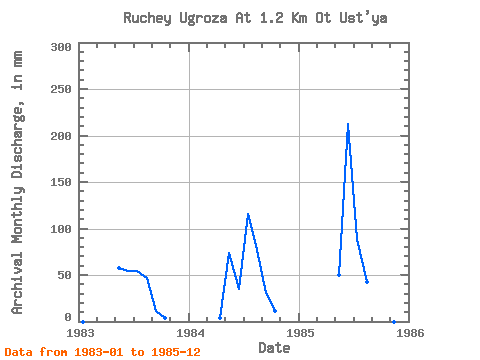
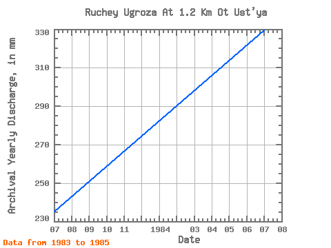
| Year | Jan | Feb | Mar | Apr | May | Jun | Jul | Aug | Sep | Oct | Nov | Dec | Annual | 1983 | 0.00 | 0.00 | 0.00 | 0.00 | 59.95 | 54.16 | 55.96 | 47.96 | 11.61 | 2.40 | 0.00 | 0.00 | 230.03 | 1984 | 0.00 | 0.00 | 0.00 | 2.32 | 75.94 | 34.82 | 119.91 | 79.94 | 30.95 | 10.39 | 0.00 | 0.00 | 350.14 | 1985 | 0.00 | 0.00 | 0.00 | 0.00 | 51.96 | 212.78 | 91.93 | 43.97 | 19.34 | 2.40 | 0.00 | 0.00 | 422.37 |
|---|
 Return to R-Arctic Net Home Page