|
|
|||||||||||||||||
| Point ID: 8130 | Downloads | Plots | Site Data | Code: 1620 |
|
|
|||||||||||||||||
| Download | |
|---|---|
| Site Descriptor Information | Site Time Series Data |
| Link to all available data | |
|
|
| View: | Statistics | Time Series |
| Units: | m3/s |
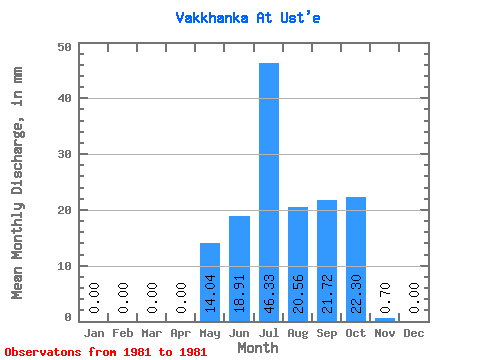
| Statistic | Jan | Feb | Mar | Apr | May | Jun | Jul | Aug | Sep | Oct | Nov | Dec | Annual |
|---|---|---|---|---|---|---|---|---|---|---|---|---|---|
| Mean | 0.00 | 0.00 | 0.00 | 0.00 | 14.05 | 18.92 | 46.32 | 20.56 | 21.72 | 22.30 | 0.70 | 0.00 | 143.33 |
| Standard Deviation | |||||||||||||
| Min | 0.00 | 0.00 | 0.00 | 0.00 | 14.05 | 18.92 | 46.32 | 20.56 | 21.72 | 22.30 | 0.70 | 0.00 | 143.33 |
| Max | 0.00 | 0.00 | 0.00 | 0.00 | 14.05 | 18.92 | 46.32 | 20.56 | 21.72 | 22.30 | 0.70 | 0.00 | 143.33 |
| Coefficient of Variation |
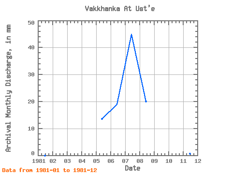
| Year | Jan | Feb | Mar | Apr | May | Jun | Jul | Aug | Sep | Oct | Nov | Dec | Annual | 1981 | 0.00 | 0.00 | 0.00 | 0.00 | 14.05 | 18.92 | 46.32 | 20.56 | 21.72 | 22.30 | 0.70 | 0.00 | 143.33 |
|---|
 Return to R-Arctic Net Home Page