|
|
|||||||||||||||||
| Point ID: 8120 | Downloads | Plots | Site Data | Code: 1601 |
|
|
|||||||||||||||||
| Download | |
|---|---|
| Site Descriptor Information | Site Time Series Data |
| Link to all available data | |
|
|
| View: | Statistics | Time Series |
| Units: | m3/s |
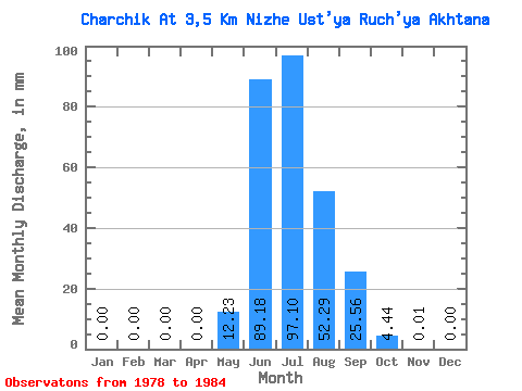
| Statistic | Jan | Feb | Mar | Apr | May | Jun | Jul | Aug | Sep | Oct | Nov | Dec | Annual |
|---|---|---|---|---|---|---|---|---|---|---|---|---|---|
| Mean | 0.00 | 0.00 | 0.00 | 0.00 | 12.24 | 89.18 | 97.09 | 52.28 | 25.56 | 4.44 | 0.01 | 0.00 | 286.05 |
| Standard Deviation | 0.00 | 0.00 | 0.00 | 0.00 | 11.05 | 33.89 | 43.33 | 9.86 | 13.22 | 2.22 | 0.04 | 0.00 | 68.91 |
| Min | 0.00 | 0.00 | 0.00 | 0.00 | 1.26 | 49.51 | 56.27 | 36.11 | 11.07 | 1.81 | 0.00 | 0.00 | 200.21 |
| Max | 0.00 | 0.00 | 0.00 | 0.00 | 32.50 | 141.98 | 168.50 | 66.05 | 47.62 | 7.67 | 0.10 | 0.00 | 382.10 |
| Coefficient of Variation | 0.90 | 0.38 | 0.45 | 0.19 | 0.52 | 0.50 | 2.65 | 0.24 |
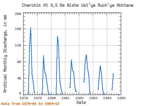
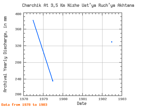
| Year | Jan | Feb | Mar | Apr | May | Jun | Jul | Aug | Sep | Oct | Nov | Dec | Annual | 1978 | 0.00 | 0.00 | 0.00 | 0.00 | 4.36 | 120.14 | 168.50 | 52.97 | 32.18 | 5.87 | 0.00 | 0.00 | 382.10 | 1979 | 0.00 | 0.00 | 0.00 | 0.00 | 2.26 | 95.09 | 56.27 | 49.65 | 27.23 | 5.27 | 0.10 | 0.00 | 235.62 | 1980 | 0.00 | 0.00 | 0.00 | 0.00 | 1.26 | 141.98 | 123.82 | 36.11 | 16.16 | 2.56 | 0.00 | 0.00 | 321.27 | 1981 | 0.00 | 0.00 | 0.00 | 0.00 | 18.36 | 85.19 | 60.93 | 57.47 | 19.08 | 7.67 | 0.00 | 0.00 | 247.63 | 1982 | 0.00 | 0.00 | 0.00 | 0.00 | 32.50 | 81.40 | 100.20 | 66.05 | 47.62 | 3.46 | 0.00 | 0.00 | 329.49 | 1983 | 0.00 | 0.00 | 0.00 | 0.00 | 13.69 | 50.97 | 72.82 | 51.45 | 11.07 | 1.81 | 0.00 | 0.00 | 200.21 | 1984 | 0.00 | 0.00 | 0.00 | 0.00 | 13.24 | 49.51 | 0.00 | 0.00 |
|---|
 Return to R-Arctic Net Home Page