|
|
|||||||||||||||||
| Point ID: 8032 | Downloads | Plots | Site Data | Code: 1043 |
|
|
|||||||||||||||||
| Download | |
|---|---|
| Site Descriptor Information | Site Time Series Data |
| Link to all available data | |
|
|
| View: | Statistics | Time Series |
| Units: | m3/s |
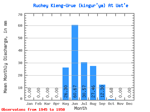
| Statistic | Jan | Feb | Mar | Apr | May | Jun | Jul | Aug | Sep | Oct | Nov | Dec | Annual |
|---|---|---|---|---|---|---|---|---|---|---|---|---|---|
| Mean | 0.00 | 0.00 | 0.00 | 0.00 | 26.28 | 60.67 | 30.56 | 27.48 | 12.30 | 0.72 | 0.00 | 0.00 | 163.31 |
| Standard Deviation | 0.00 | 0.00 | 0.00 | 0.00 | 25.05 | 51.33 | 19.87 | 17.49 | 12.04 | 0.47 | 0.00 | 0.00 | 101.85 |
| Min | 0.00 | 0.00 | 0.00 | 0.00 | 0.00 | 7.51 | 11.64 | 4.75 | 3.06 | 0.19 | 0.00 | 0.00 | 51.95 |
| Max | 0.00 | 0.00 | 0.00 | 0.00 | 61.13 | 133.36 | 65.98 | 49.48 | 29.11 | 1.36 | 0.00 | 0.00 | 277.68 |
| Coefficient of Variation | 0.95 | 0.85 | 0.65 | 0.64 | 0.98 | 0.66 | 0.62 |
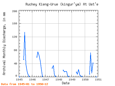
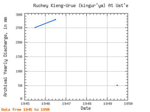
| Year | Jan | Feb | Mar | Apr | May | Jun | Jul | Aug | Sep | Oct | Nov | Dec | Annual | 1945 | 0.00 | 0.00 | 0.00 | 0.00 | 53.37 | 133.36 | 39.78 | 16.50 | 6.76 | 0.39 | 0.00 | 0.00 | 250.23 | 1946 | 0.00 | 0.00 | 0.00 | 0.00 | 61.13 | 75.13 | 65.98 | 49.48 | 26.30 | 1.36 | 0.00 | 0.00 | 277.68 | 1947 | 0.00 | 0.00 | 0.00 | 0.00 | 0.00 | 27.17 | 34.93 | 5.07 | 1.07 | 0.00 | 0.00 | 1948 | 0.00 | 0.00 | 0.00 | 0.00 | 20.38 | 15.03 | 16.50 | 16.50 | 3.48 | 0.19 | 0.00 | 0.00 | 71.37 | 1949 | 0.00 | 0.00 | 0.00 | 0.00 | 14.55 | 7.51 | 22.32 | 4.75 | 3.06 | 0.35 | 0.00 | 0.00 | 51.95 | 1950 | 0.00 | 0.00 | 0.00 | 0.00 | 8.25 | 72.31 | 11.64 | 42.69 | 29.11 | 0.97 | 0.00 | 0.00 | 165.33 |
|---|
 Return to R-Arctic Net Home Page