|
|
|||||||||||||||||
| Point ID: 8029 | Downloads | Plots | Site Data | Code: 1035 |
|
|
|||||||||||||||||
| Download | |
|---|---|
| Site Descriptor Information | Site Time Series Data |
| Link to all available data | |
|
|
| View: | Statistics | Time Series |
| Units: | m3/s |
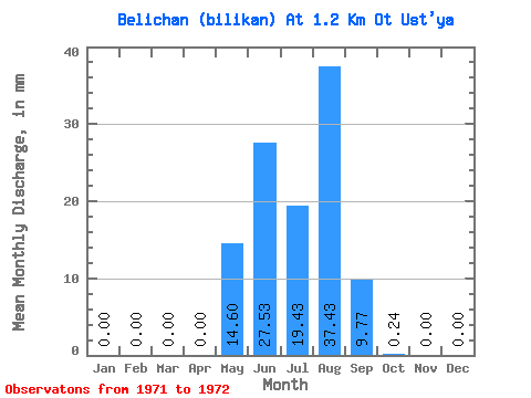
| Statistic | Jan | Feb | Mar | Apr | May | Jun | Jul | Aug | Sep | Oct | Nov | Dec | Annual |
|---|---|---|---|---|---|---|---|---|---|---|---|---|---|
| Mean | 0.00 | 0.00 | 0.00 | 0.00 | 14.60 | 27.53 | 19.43 | 37.43 | 9.77 | 0.24 | 0.00 | 0.00 | 108.26 |
| Standard Deviation | 0.00 | 0.00 | 0.00 | 0.00 | 1.10 | 4.06 | 17.54 | 43.00 | 10.52 | 0.01 | 0.00 | 0.00 | 40.86 |
| Min | 0.00 | 0.00 | 0.00 | 0.00 | 13.83 | 24.66 | 7.02 | 7.02 | 2.34 | 0.23 | 0.00 | 0.00 | 79.37 |
| Max | 0.00 | 0.00 | 0.00 | 0.00 | 15.38 | 30.39 | 31.83 | 67.84 | 17.21 | 0.24 | 0.00 | 0.00 | 137.16 |
| Coefficient of Variation | 0.07 | 0.15 | 0.90 | 1.15 | 1.08 | 0.03 | 0.38 |
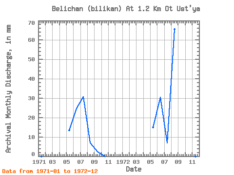
| Year | Jan | Feb | Mar | Apr | May | Jun | Jul | Aug | Sep | Oct | Nov | Dec | Annual | 1971 | 0.00 | 0.00 | 0.00 | 0.00 | 13.83 | 24.66 | 31.83 | 7.02 | 2.34 | 0.24 | 0.00 | 0.00 | 79.37 | 1972 | 0.00 | 0.00 | 0.00 | 0.00 | 15.38 | 30.39 | 7.02 | 67.84 | 17.21 | 0.23 | 0.00 | 0.00 | 137.16 |
|---|
 Return to R-Arctic Net Home Page